
| Area | Basin-wide/Regional |
| Topic | Stream Channel: Thalweg Profile - Russian R - Alexander Valley 1972-98 |
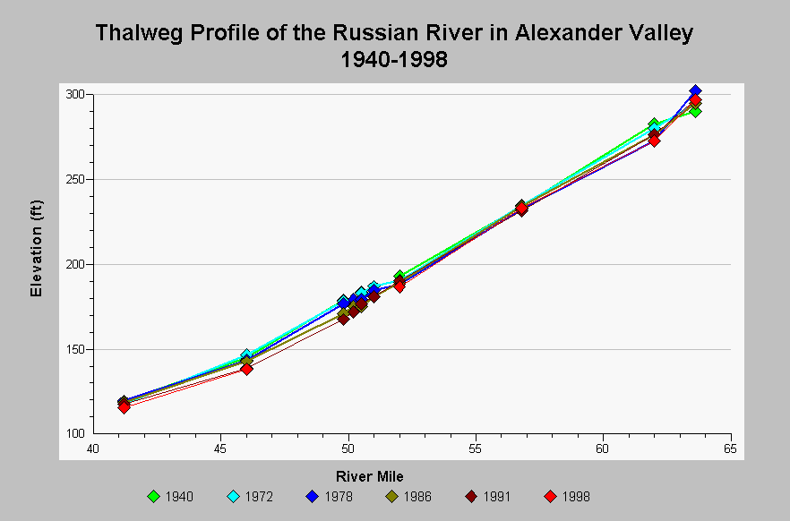
| Caption: This chart shows thalweg profiles for the Russian River in Alexander Valley over the years 1940 to 1998. Channel degradation is dominant between river mile 40 to 52 and at river mile 62. Between 1940 and 1998, degradation up to 11.5 feet has occurred at river mile 49.8 and 10.1 feet at river mile 62. The channel has remained stable at river mile 65.8. Twelve feet of aggradation occurred at river mile 63.6 between 1940 and 1978, which then degraded 5 feet by 1998. Lines are added to the graph to resolve differences at the data point and are not intended to interpolate elevations between points. The thalweg data come from Sonoma County Water Agency cross-section data that was collected as part of the Russian River Aggregate Resource Management monitoring. Cross-section data pre-dating 1991 were digitized from digitized from SCWA cross-sectional blue prints by NW Hydraulics. Thalweg elevations for river mile 50.2 to 51.0 come from the 1994 Russian River Aggregate Resources Management Plan. See InfoLinks for more information. | |
 |
To learn more about this topic click Info Links .
To view additional information (data source, aquisition date etc.) about this page, click Metadata .
To view the table with the chart's data, click Chart Table web page.
To download the table with the chart's data, click streamchannel_thalweg_russian_alxndr_1938_1998.dbf (size 3,826 bytes) .
| www.krisweb.com |