
| Area | Basin-wide/Regional |
| Topic | Stream Channel: Thalweg Profile - Russian R - Middle Reach 1940-1989 |
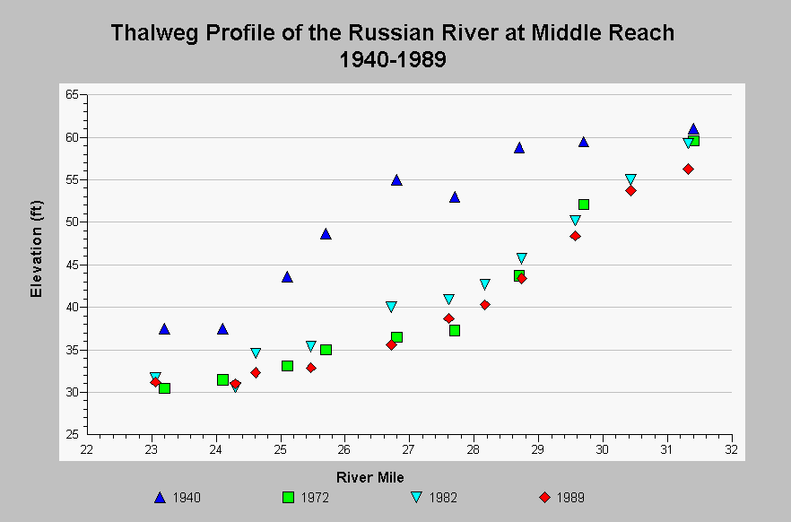
| Caption: This chart shows thalweg profiles for the Russian River in the Middle Reach over the years 1940 to 1989. Significant channel down-cutting occurred from 1940 to 1972, averaging 11.5 ft of degradation with up to 18.5 ft at river mile 26.8, representing a volume of about 10 million tons of gravel (CDMG, 1990). Between 1972 and 1989, channel degradation continued above river mile 29. Other areas aggraded in 1982 and then degraded by 1989. Data from 1940 and 1972 come from surveys conducted by the US Army Corps of Engineers; other surveys were conducted by Sonoma County Water Agency. See InfoLinks for more information. | |
 |
To learn more about this topic click Info Links .
To view additional information (data source, aquisition date etc.) about this page, click Metadata .
To view the table with the chart's data, click Chart Table web page.
To download the table with the chart's data, click streamchannel_thalweg_russian_middle_1940_1989.dbf (size 1,326 bytes) .
| www.krisweb.com |