
| Area | Forsythe Creek |
| Topic | Sediment: Road Densities for Forsythe Creek Calwaters |
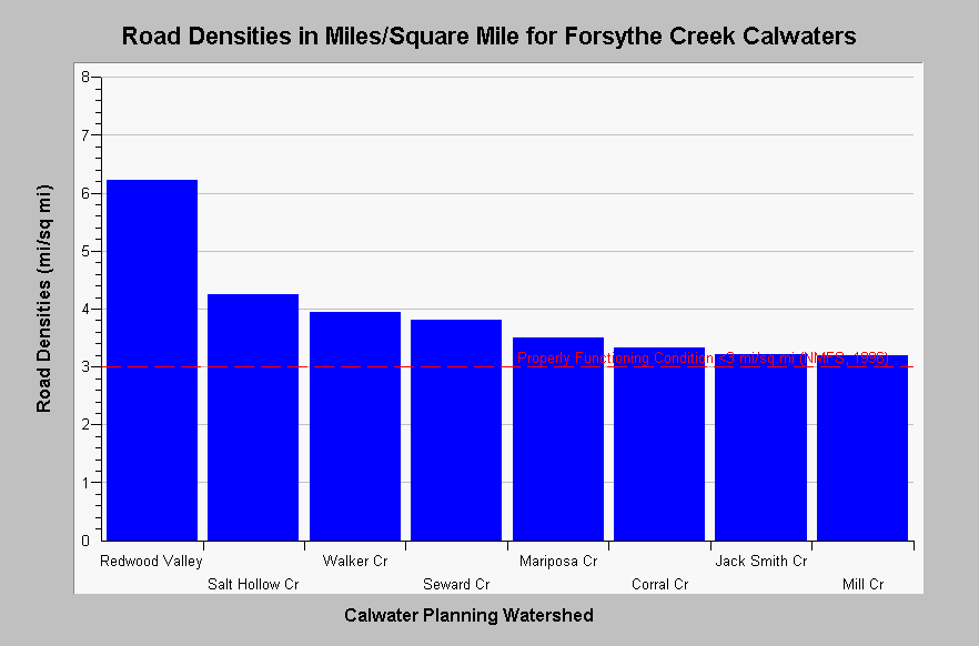
| Caption: The chart above shows a summary of road densities in miles per square mile for the Forsythe Creek Calwater Planning Watersheds. All Calwater Planning Watersheds have densities exceeding properly functioning condition according to the National Marine Fisheries Service (1996), which is less than 3 miles per square mile, a value shown for reference. Cedarholm, et. al. (1981) suggests that road densities should not exceed 1.6 mi/sq. mi. Road data originates from 1:24,000 scale topographic maps and under represent road densities, especially in urban and timber harvest areas. Roads densities are calculated by KRIS IFR staff in Arc Info. See Map for a map layer of basin wide roads. See InfoLinks for more information. | |
 |
To learn more about this topic click Info Links .
To view additional information (data source, aquisition date etc.) about this page, click Metadata .
To view the table with the chart's data, click Chart Table web page.
To download the table with the chart's data, click roads_russian_forsythecr_24k.dbf (size 2,462 bytes) .
To view the table with the chart's source data, click Source Table web page.
To download the table with the chart's source data, click roads_russian_calwaters_24k.dbf (size 27,124 bytes)
| www.krisweb.com |