
| Area | Guerneville |
| Topic | Land Cover: USFS Veg Size - Guerneville Calwaters 1999 |
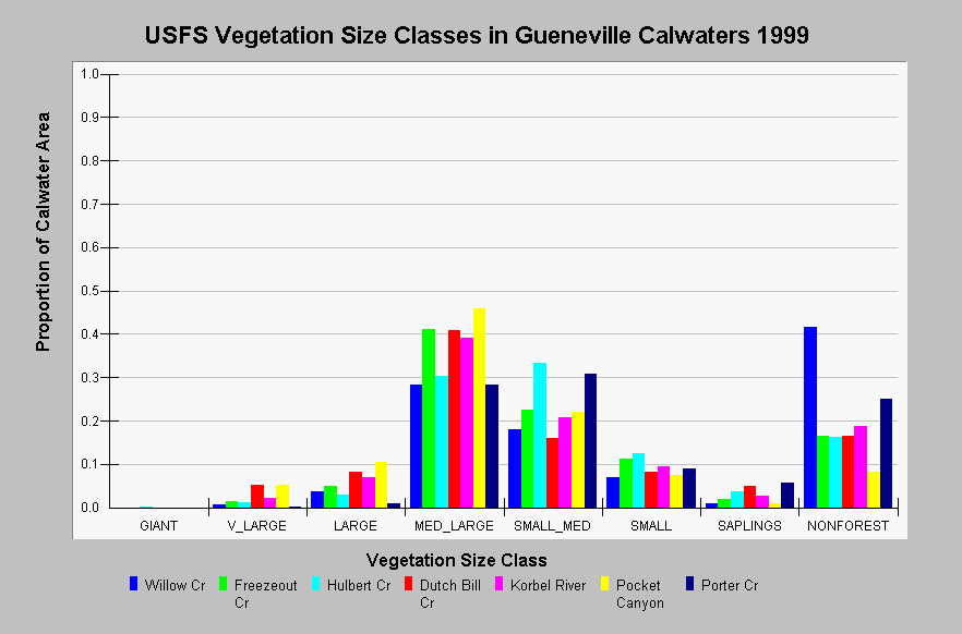
| Caption: This chart shows vegetation coverage by size classes for a subset of Guerneville Calwater Planning Watersheds. Data are derived from a 1999 Landsat image by the U.S. Forest Service. The majority of the forested areas contain medium/large and small/medium trees with less coverage of small trees, large trees, and saplings. There are few very large trees (<5.2%) in these Calwater Planning Watersheds. The only giant trees are in Hulbert Creek and covers 0.1% of that Calwater. The vegetation classification is accurate at a one-hectare scale and is suitable for stand classification. Click on Map to see spatial data. Vegetation is classified according to diameter at breast height (DBH): Giant > 50", Very Large = 40-50" DBH, Large = 30-39.9" DBH, Medium/Large = 20-29.9" DBH, Small/Medium = 12-19.9" DBH, Small = 5-11.9" DBH, Saplings = 1-4.9" DBH, Non-Forest = No trees, shrubs, grass, bare soil. Click on InfoLinks for more information. | |
 |
To learn more about this topic click Info Links .
To view additional information (data source, aquisition date etc.) about this page, click Metadata .
To view the table with the chart's data, click Chart Table web page.
To download the table with the chart's data, click vegsize_usfs_guerneville.dbf (size 1,394 bytes) .
To view the table with the chart's source data, click Source Table web page.
To download the table with the chart's source data, click vegsize_usfs_russian_calwaters.dbf (size 16,230 bytes)
| www.krisweb.com |