
| Area | Guerneville |
| Topic | Temperature: Russian R. in Guern. Sub-basin, MWAT by Year 1999-2002 |
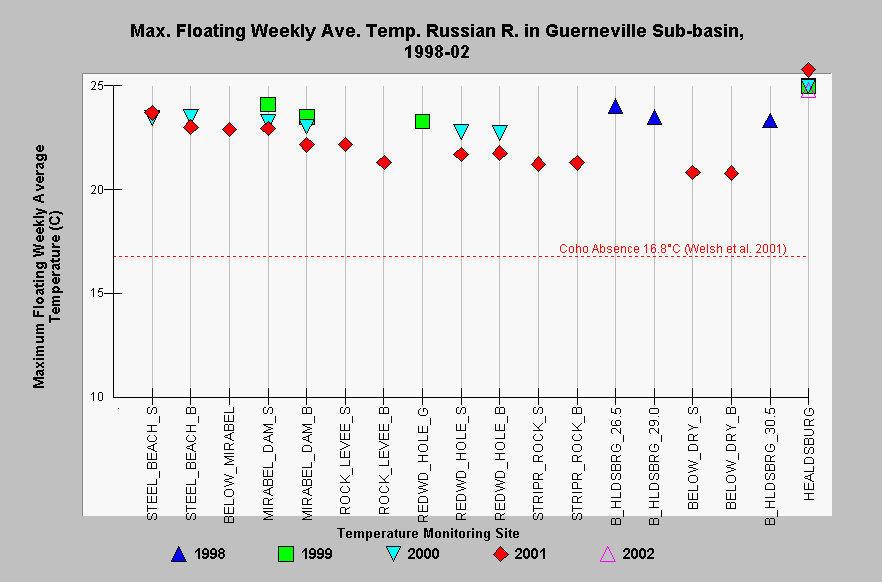
| Caption: This Chart shows maximum floating weekly average temperature (MWAT) for each site in the Guerneville sub-basin with available data in the years 1998-2002. Sites are listed in upstream order, beginning on the left side of the chart with the lowest site and ending with the uppermost site on the far right. The Russian River is cooled below its confluence with Dry Creek due to cold water released from warm springs dam, then it warms slowly as it flows 15 kilometers to Steelhead Beach. Unfortunately, there are no temperature data available for the lower 36 kilometers of the river. MWATs exceeded both reference values at all mainstem Russian River sites in the Guerneville sub-basin. Welsh et al. (2001) found that coho are not likely to persist where MWAT exceeds 16.8°C. See InfoLinks for more information. Data were provided by Sonoma County Water Agency and California Department of Water Resources. | |
 |
To learn more about this topic click Info Links .
To view additional information (data source, aquisition date etc.) about this page, click Metadata .
To view the table with the chart's data, click Chart Table web page.
To download the table with the chart's data, click temp_rus_gu_main_mwatchart.db (size 18,432 bytes) .
| www.krisweb.com |