
| Area | Guerneville |
| Topic | WQ: Estuary 1996 Hydrolab Temp, Salinity and DO Station #3 Oct-Nov |
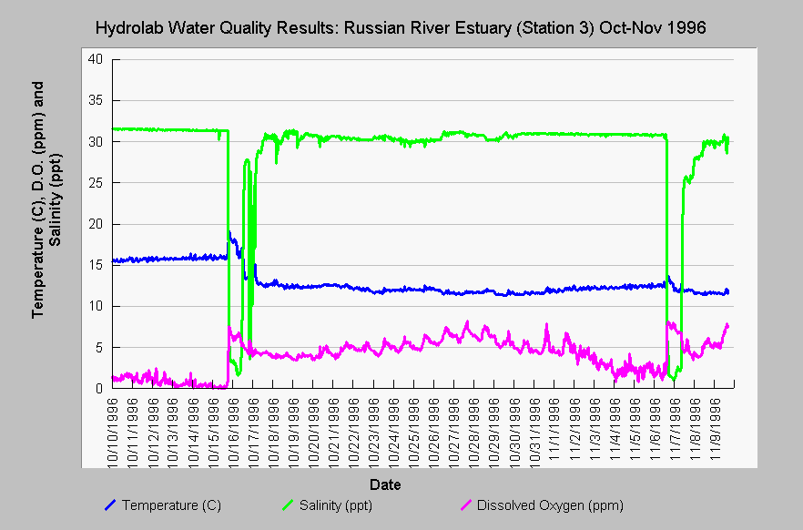
| Caption: The salinity, dissolved oxygen and temperature of the Russian River estuary near the mouth of Willow Creek (Station #3) are shown above from October 10 to November 9, 1996 (see Picture tab for map). Dissolved oxygen was at very depressed levels for fish life prior to the October 16 breaching and DO sags were beginning to recur when the estuary was breached again on November 7, 1996. Note that this deep hole off Willow Creek takes several tidal cycles to fully re-oxygenate bottom waters. Cyclic fluctuations are as a result of new oxygen rich sea water intruding with high tides. Data are from Merritt Smith Consulting (1997) and Sonoma County. See InfoLinks for more information. | |
 |
To learn more about this topic click Info Links .
To view additional information (data source, aquisition date etc.) about this page, click Metadata .
To view the table with the chart's data, click Chart Table web page.
To download the table with the chart's data, click wq_sal_do_temp_est_sta32_oct1996.dbf (size 53,190 bytes) .
To view the table with the chart's source data, click Source Table web page.
To download the table with the chart's source data, click wq_sonds_1996_mega_source_1_3_4.dbf (size 392,978 bytes)
| www.krisweb.com |