
| Area | Guerneville |
| Topic | WQ: Estuary 1997 Hydrolab Temp, Salinity and DO Station #2 July-Sept |
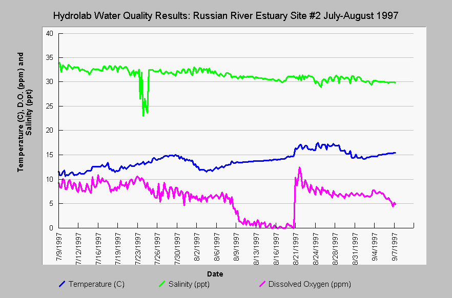
| Caption: The water quality data summarized in this chart is from an automated Hydrolab probe placed at Station #2 below Highway 1 in the Russian River estuary and shows temperature in Celsius, salinity in parts per thousand, dissolved oxygen in parts per million. The probe was deployed just after a breaching event on July 1, which accounts for the relatively high DO and salinity and low water temperature. Dissolved oxygen started to drop in late July and was not replenished until the estuary was breached again on August 21, 1997. Note that the lag time for recovery of DO at Station #2 is shorter than that at Station #3, which is further from the ocean (See Picture tab for map). | |
 |
To learn more about this topic click Info Links .
To view additional information (data source, aquisition date etc.) about this page, click Metadata .
To view the table with the chart's data, click Chart Table web page.
To download the table with the chart's data, click wq_sond_2_1997.dbf (size 16,338 bytes) .
To view the table with the chart's source data, click Source Table web page.
To download the table with the chart's source data, click wq_sond_1997_source_1_2_3_4.dbf (size 87,023 bytes)
| www.krisweb.com |