
| Area | Guerneville |
| Topic | WQ: Estuary 1999 Hydrolab Temp, Salinity and DO Station #4 June-July |
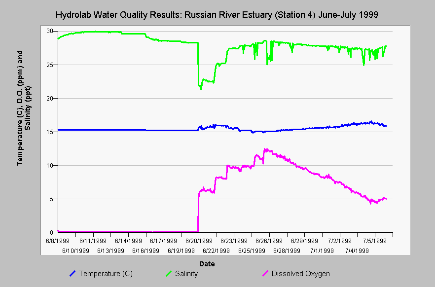
| Caption: An automated Hydrolab data probe was placed in the deepest part of the Russian River estuary channel just down stream of Sheephouse Creek (Station #4) from June 8 to July 6, 1999 and temperature, salinity and dissolved oxygen measurements are shown above. MSC (2000) noted that: "Datasonde records from Station 4 show that near bottom anoxia was not relieved until five days after the breaching of 15 June, and was accompanied by a salinity decrease of 7 ppt. Near-bottom DO at Station 4 declined gradually during the closure beginning 24 June, and the decline continued for several days after the breaching of 1 July (Event I). DO gradually increased beginning on 7 July." See the Picture tab for monitoring locations. Click on InfoLinks for more information. | |
 |
To learn more about this topic click Info Links .
To view additional information (data source, aquisition date etc.) about this page, click Metadata .
To view the table with the chart's data, click Chart Table web page.
To download the table with the chart's data, click wq_datasond_sta4_source_raw_1999_june_july.dbf (size 24,354 bytes) .
| www.krisweb.com |