
| Area | Guerneville |
| Topic | WQ: Estuary Temp, Salinity and DO Grab Sta #1 8/18/97 Pre-Breaching |
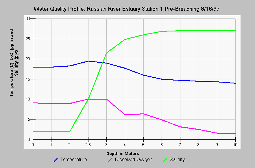
| Caption: This chart shows the Russian River estuary temperature in Celsius, dissolved oxygen (DO) in parts per million (ppm) and salinity in parts per thousand (ppt) at Station #1 versus the depth in meters before the estuary was breached. The salinity of the water was near fresh in the first two meters but salinity increased at depth. Both the temperature and the DO dropped with depth, with the latter slipping into stressful ranges for salmonids (<5 ppm) at depths greater than six meters. This station is immediately upstream of the mouth of the Russian River and breaching ameliorates dissolved oxygen problems as oxygen rich sea water intrudes (see next Topics). Data provided by Merritt-Smith Consulting (1998) from a study performed for Sonoma County. See InfoLinks for more information on study methods and results. | |
 |
To learn more about this topic click Info Links .
To view additional information (data source, aquisition date etc.) about this page, click Metadata .
To view the table with the chart's data, click Chart Table web page.
To download the table with the chart's data, click wq_8_18_97_grab_pre.dbf (size 770 bytes) .
To view the table with the chart's source data, click Source Table web page.
To download the table with the chart's source data, click wq_profiles_1997_mega_source.dbf (size 57,960 bytes)
| www.krisweb.com |