
| Area | Guerneville |
| Topic | WQ: Estuary Temp, Salinity and DO Grab Sta #2 11/7/2000 Pre-Breaching |
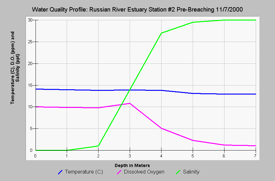
| Caption: This chart shows the Russian River estuary temperature in Celsius, dissolved oxygen (DO) in parts per million (ppm) and salinity in parts per thousand (ppt) at Station #2 versus the depth in meters before the estuary was breached on November 7, 2000. The salinity of the water was near fresh in the first two meters but salinity increased below two meters. The temperature remained relatively stable at depth but the DO dropped with to stressful or lethal ranges for salmonids (<5 ppm) at depths greater than four meters. See Picture tab for map. Data provided by Merritt-Smith Consulting (2001) from a study performed for Sonoma County. See InfoLinks for more information on study methods and results. | |
 |
To learn more about this topic click Info Links .
To view additional information (data source, aquisition date etc.) about this page, click Metadata .
To view the table with the chart's data, click Chart Table web page.
To download the table with the chart's data, click wq_grab_sta2_nov_7_2000.dbf (size 2,090 bytes) .
To view the table with the chart's source data, click Source Table web page.
To download the table with the chart's source data, click wq_grab_nov_2000_event_iv.dbf (size 7,130 bytes)
| www.krisweb.com |