
| Area | Guerneville |
| Topic | WQ: Estuary Temp, Salinity and DO Grab Sta #2 11/8/00 During Breach |
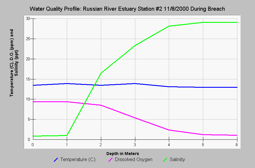
| Caption: This chart shows the Russian River estuary temperature in Celsius, dissolved oxygen (DO) in parts per million (ppm) and salinity in parts per thousand (ppt) at Station #2 versus the depth in meters during breaching on November 8, 2000. There was very little change in water quality during breaching with dissolved oxygen remaining depressed below three meters. Data provided by Merritt-Smith Consulting (2001) from a study performed for Sonoma County. See InfoLinks for more information on study methods and results. | |
 |
To learn more about this topic click Info Links .
To view additional information (data source, aquisition date etc.) about this page, click Metadata .
To view the table with the chart's data, click Chart Table web page.
To download the table with the chart's data, click wq_grab_sta2_nov_8_2000.dbf (size 2,090 bytes) .
To view the table with the chart's source data, click Source Table web page.
To download the table with the chart's source data, click wq_grab_sta2_nov2000.dbf (size 2,090 bytes)
| www.krisweb.com |