
| Area | Guerneville |
| Topic | WQ: Estuary Temp, Salinity and DO Grab Sta #4 10/9/1996 Pre-Breaching |
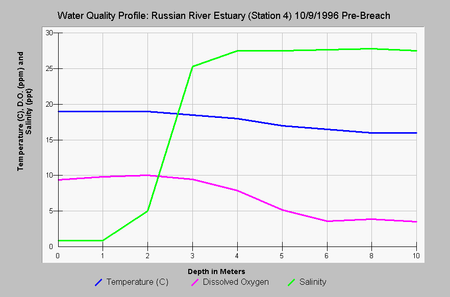
| Caption: Station 4 on the Russian River estuary is the furthest upstream of the mouth (see Picture tab for map) and salinity, temperature, and dissolved oxygen at varying depths are shown on this chart for October 9, 1996 just before breaching of the estuary. Stratification is evident as the salinity of the water increased at depth and both the temperature and the DO dropped, with the latter slipping into stressful ranges for salmonids below five meters (< 5 ppm). Temperature moderated only slightly at depth. Data provided by Merritt-Smith Consulting from a study performed for Sonoma County. See InfoLinks for more information on study methods and results. | |
 |
To learn more about this topic click Info Links .
To view additional information (data source, aquisition date etc.) about this page, click Metadata .
To view the table with the chart's data, click Chart Table web page.
To download the table with the chart's data, click wq_grab_sta4_oct9_96.dbf (size 1,870 bytes) .
To view the table with the chart's source data, click Source Table web page.
To download the table with the chart's source data, click wq_profiles_1996_mega_source.dbf (size 16,880 bytes)
| www.krisweb.com |