
| Area | Geyserville |
| Topic | Habitat: Survey Reach Length in Franz Cr and Tribs 1997 |
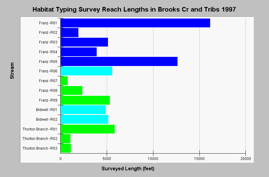
| Caption: The chart shows the total length in feet of 1997 California Department of Fish and Game habitat typing surveys for reaches in Franz Creek and its tributaries Thorton Branch and Bidwell Creeks. Streams were typically surveyed from their mouths upstream to the end of anadromy, but sometimes property access constraints prematurely ended surveys, or portions of the stream were skipped, possibly resulting in a less accurate picture of habitat conditions than complete surveys. Strahler stream orders of tributaries were determined by IFR-KRIS using the California Department of Forestry's 1:24,000 scale GIS layer and are color coded in this chart with dark blue = 4th order and light blue = 3rd order. See InfoLinks for more information. | |
 |
To learn more about this topic click Info Links .
To view additional information (data source, aquisition date etc.) about this page, click Metadata .
To view the table with the chart's data, click Chart Table web page.
To download the table with the chart's data, click hab_cdfg_gy_franz_1997.dbf (size 19,654 bytes) .
To view the table with the chart's source data, click Source Table web page.
To download the table with the chart's source data, click hab_cdfg_rus_94_01_source.dbf (size 299,436 bytes)
| www.krisweb.com |