
| Area | Geyserville |
| Topic | Temperature: Floating Weekly Avg, Middle Geyserville Tribs, 2001 |
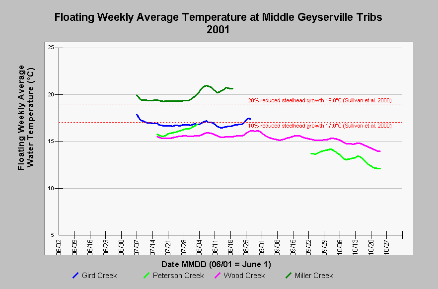
| Caption: This Chart shows the floating weekly average water temperature at four streams in the middle portion of of the Geyserville sub-basin for the year 2001. The records for Gird, Peterson, and Miller Creeks are all cut short because the creeks dried up at the monitoring sites. The Peterson Creek probe was discovered dry in September and was redeployed at another location. Maximum floating weekly average water temperatures (MWAT) exceeded 17.0°C at two of four sites, and exceed 19.0°C at Miller Creek. Temperatures in Wood Creek were excellent for salmonids. Based on a review of steelhead growth studies, Sullivan et al. (2000) found that compared to optimum temperatures, an MWAT of 17.0°C reduced steelhead growth by 10%, and an MWAT of 19.0°C reduced growth by 20%. See InfoLinks for more information. Temperature data comes from automated water temperature data probes placed in the Russian River and its tributaries by the California Department of Fish and Game. | |
 |
To learn more about this topic click Info Links .
To view additional information (data source, aquisition date etc.) about this page, click Metadata .
To view the table with the chart's data, click Chart Table web page.
To download the table with the chart's data, click temp_cdfg_rus_00_01_daily.db (size 219,136 bytes) .
To view the table with the chart's source data, click Source Table web page.
To download the table with the chart's source data, click temperature_proxy.dbf (size 80 bytes)
| www.krisweb.com |