
| Area | Mark West |
| Topic | Habitat: Habitat Types by Length in Mark West Cr and Tribs 1996-1997 |
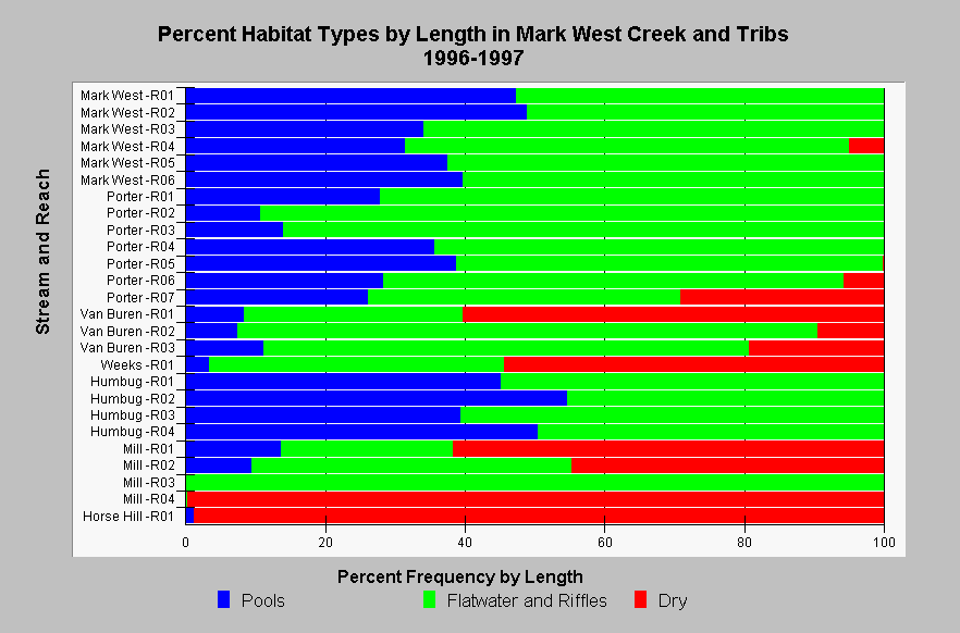
| Caption: This chart shows a summary of habitat types by length from California Department of Fish and Game (CDFG) habitat typing surveys in Mark West Creek and its tributaries in 1996-1997. Streams in the chart are sorted by Strahler order (with larger streams at the top), and reaches are numbered upstream beginning at stream mouths. Only five of 19 reaches contained at least 40% pools by length. CDFG stream survey reports state, "In general, pool enhancement projects are considered when primary pools comprise less than 40% of the length of total stream habitat." There are extensive dry sections in Mill, Van Buren, Weeks, Mill, Horse Hill, and some dry sections in the fourth reach of Mark West. Riffles and flatwater are combined in this graph because CDFG reach summaries did not separate them. See InfoLinks for more information. | |
 |
To learn more about this topic click Info Links .
To view additional information (data source, aquisition date etc.) about this page, click Metadata .
To view the table with the chart's data, click Chart Table web page.
To download the table with the chart's data, click hab_cdfg_mw_mwest_96_97.dbf (size 34,798 bytes) .
To view the table with the chart's source data, click Source Table web page.
To download the table with the chart's source data, click hab_cdfg_rus_94_01_source.dbf (size 299,436 bytes)
| www.krisweb.com |