
| Area | Ukiah |
| Topic | Flow: EF Russian R nr Ukiah, CA - Daily Ave 1976-1988 |
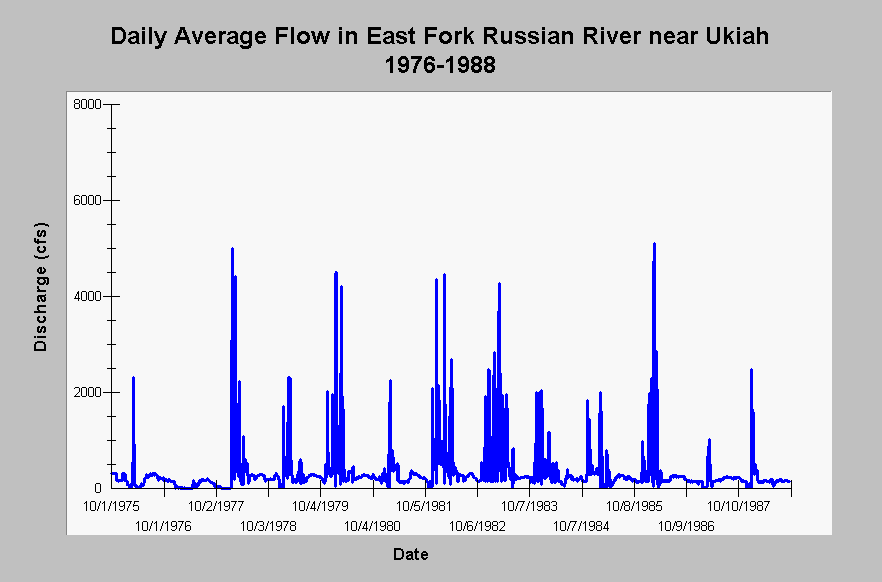
| Caption: This chart displays daily average flows (cfs) in the East Fork Russian River near Ukiah, CA (US Geological Survey gauging station #11462000) for the water years 1976 through 1988. The East Fork Russian River stream flow has been under the influence of the Potter Valley Project diversion since 1908. Flows during and after 1958 are influenced by the Coyote Dam. See InfoLinks for more information. | |
 |
To learn more about this topic click Info Links .
To view additional information (data source, aquisition date etc.) about this page, click Metadata .
To view the table with the chart's data, click Chart Table web page.
To download the table with the chart's data, click flow_daily_usgs11462000_efrus_nr_uk_1976_1988.dbf (size 171,126 bytes) .
To view the table with the chart's source data, click Source Table web page.
To download the table with the chart's source data, click flow_daily_usgs11462000_efrus_nr_uk_1912_2001.dbf (size 666,450 bytes)
| www.krisweb.com |