
| Area | Ukiah |
| Topic | Habitat: Canopy in West Ukiah Tribs 1995-2001 |
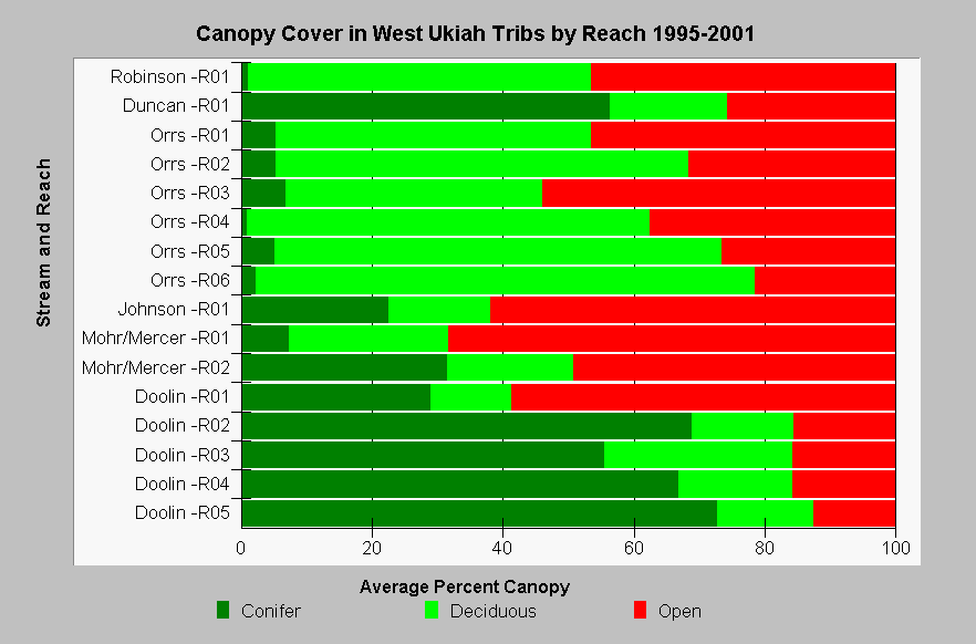
| Caption: This chart shows the canopy density in western streams in the Ukiah sub-basin as measured during 1995, 1998, 1999, and 2001 California Department of Fish and Game (CDFG) habitat typing surveys. Streams in the chart are sorted by Strahler order (with larger streams at the top), and reaches are numbered upstream beginning at stream mouths. Canopy density in the streams was relatively poor. Out of a total of 16 reaches, the 4 middle and upper reaches of Doolin Creek were the only reaches with greater than 80% canopy. Lack of canopy can contribute to stream warming. CDFG stream survey reports state, "In general, revegetation projects are considered when canopy density is less than 80%." Click Map to see canopy density for the stream reaches. See InfoLinks for more information. | |
 |
To learn more about this topic click Info Links .
To view additional information (data source, aquisition date etc.) about this page, click Metadata .
To view the table with the chart's data, click Chart Table web page.
To download the table with the chart's data, click hab_cdfg_uk_west_95_01.dbf (size 22,466 bytes) .
To view the table with the chart's source data, click Source Table web page.
To download the table with the chart's source data, click hab_cdfg_rus_94_01_source.dbf (size 299,436 bytes)
| www.krisweb.com |