
| Area | Warm Springs |
| Topic | Flow: Dry Cr nr Geyserville - Pre/Post 1983 - Monthly Flow Comparison |
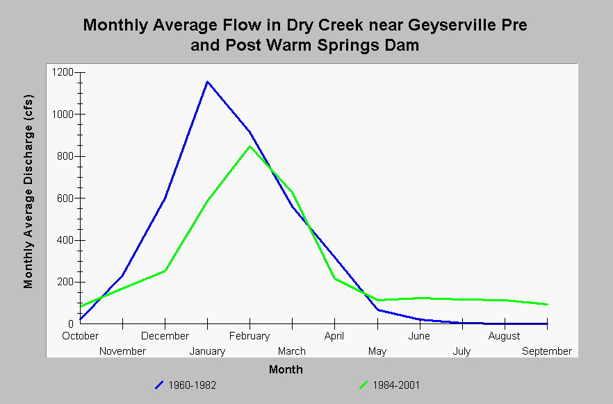
| Caption: This chart displays monthly average flows for Dry Creek near Geyserville, CA (US Geological Survey gage station #11465200), comparing the hydrographs pre- and post- influence of Warm Springs Dam. The introduction of Warm Springs Dam in 1984 has altered the magnitudes and timing of the natural monthly hydrograph. Average winter flow magnitudes have been reduced and summer base flows have increased. Additionally, the rising limb of the monthly hydrograph rises at a slower rate and peaks one month later prior to pre-dam impact. This analysis was completed by IFR-KRIS staff hydrologist and utilized daily average flow data from the USGS and the Indicators of Hydrologic Alteration (IHA) flow statistics model. See InfoLinks for more information. | |
 |
To learn more about this topic click Info Links .
To view additional information (data source, aquisition date etc.) about this page, click Metadata .
To view the table with the chart's data, click Chart Table web page.
To download the table with the chart's data, click flow_usgs11465000_drycreek_monthlyalteration.dbf (size 478 bytes) .
| www.krisweb.com |