| Basin |
Sheepscot |
| Caption |
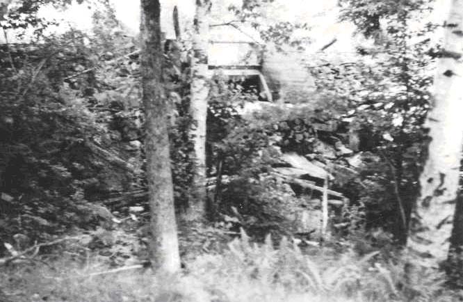
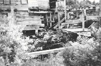
Lovejoy Stream, tributary to Sheepscot River, July 6, 1950. View of Colby's Mill dam, located approximately 3.5miles above the mouth. Has an 11 ft. high dam, with a center spillway jump height of 7 ft. Impassable to fish. Sawmill operating whenever he can pond enough water. Reports stream practically dry June thru Oct. of last year. |
| CaptionTemplate |
[Description] |
| Category |
Historical Photos |
| Description |
Lovejoy Stream, tributary to Sheepscot River, July 6, 1950. View of Colby's Mill dam, located approximately 3.5miles above the mouth. Has an 11 ft. high dam, with a center spillway jump height of 7 ft. Impassable to fish. Sawmill operating whenever he can pond enough water. Reports stream practically dry June thru Oct. of last year. |
| Filename |
colbys_mill.jpg |
| Filesize |
74075 |
| Meta_Id |
Photo_Historic |
| Notefile |
sheepscot.htm#Pics_Historic1 |
| Path |
us/colbys_mill.jpg |
| Series |
Historical Photos- 1950 Lovejoy Stream |
| SubBasin |
Upper Sheepscot |

| Basin |
Sheepscot |
| Caption |
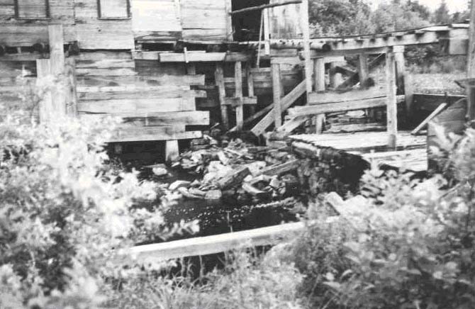
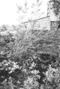
Lovejoy Stream, tributary to Sheepscot River, July 6, 1950. Dodge Mill and part of dam and dry spillway from below. Pond above is sedimented (sawdust and silt) and weed filled. |
| CaptionTemplate |
[Description] |
| Category |
Historical Photos |
| Description |
Lovejoy Stream, tributary to Sheepscot River, July 6, 1950. Dodge Mill and part of dam and dry spillway from below. Pond above is sedimented (sawdust and silt) and weed filled. |
| Filename |
dodge_mill1.jpg |
| Filesize |
51229 |
| Meta_Id |
Photo_Historic |
| Notefile |
sheepscot.htm#Pics_Historic1 |
| Path |
us/dodge_mill1.jpg |
| Series |
Historical Photos- 1950 Lovejoy Stream |
| SubBasin |
Upper Sheepscot |
| Basin |
Sheepscot |
| Caption |
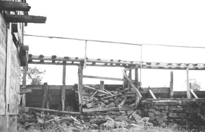
Lovejoy Stream, Tributary to Sheepscot River, at upper end of Long Pond (18.5 miles up Sheepscot) July 6, 1950. View of Dodge's Shingle Mill Dam from lower side. Stone dam has a center spillway with a 5' drop to tailwater. Dam leaks and there was no spill over the dam. Impassable to fish. Dam is located approximately 3/4 mile above mouth of Lovejoy Stream and above a marshy section. Mill is still operated on occasion. Lovejoy Stream is approximately 10-miles long, including so-called Turner Branch above Colby's Mill pond. |
| CaptionTemplate |
[Description] |
| Category |
Historical Photos |
| Description |
Lovejoy Stream, Tributary to Sheepscot River, at upper end of Long Pond (18.5 miles up Sheepscot) July 6, 1950. View of Dodge's Shingle Mill Dam from lower side. Stone dam has a center spillway with a 5' drop to tailwater. Dam leaks and there was no spill over the dam. Impassable to fish. Dam is located approximately 3/4 mile above mouth of Lovejoy Stream and above a marshy section. Mill is still operated on occasion. Lovejoy Stream is approximately 10-miles long, including so-called Turner Branch above Colby's Mill pond. |
| Filename |
dodge_mill2.jpg |
| Filesize |
76694 |
| Meta_Id |
Photo_Historic |
| Notefile |
sheepscot.htm#Pics_Historic1 |
| Path |
us/dodge_mill2.jpg |
| Series |
Historical Photos- 1950 Lovejoy Stream |
| SubBasin |
Upper Sheepscot |
| Basin |
Sheepscot |
| Caption |
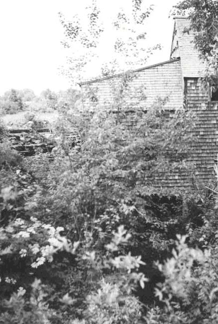
Lovejoy Stream, Tributary to Sheepscot R. July 6, 1950. French's Mill and stone dam. Tailrace from the power wheel comes from under mill in center of picture. A flood and bypass channel from the mill pond comes down from left end of dam and joins the tailrace channel below the road bridge. Fish may pass dam via bypass if not blocked by flashboards. Present mill built 60 years ago after one owned by French's grandfather had been torn down. Mill not running at present, but may. Dam located approximately 1.5 miles above mouth. |
| CaptionTemplate |
[Description] |
| Category |
Historical Photos |
| Description |
Lovejoy Stream, Tributary to Sheepscot R. July 6, 1950. French's Mill and stone dam. Tailrace from the power wheel comes from under mill in center of picture. A flood and bypass channel from the mill pond comes down from left end of dam and joins the tailrace channel below the road bridge. Fish may pass dam via bypass if not blocked by flashboards. Present mill built 60 years ago after one owned by French's grandfather had been torn down. Mill not running at present, but may. Dam located approximately 1.5 miles above mouth. |
| Filename |
french's_mill.jpg |
| Filesize |
78825 |
| Meta_Id |
Photo_Historic |
| Notefile |
sheepscot.htm#Pics_Historic1 |
| Path |
us/french's_mill.jpg |
| Photographer |
Melissa Laser |
| Series |
Historical Photos- 1950 Lovejoy Stream |
| SubBasin |
Upper Sheepscot |