
| Area | Basin-wide/Regional |
| Topic | Fish: Atl. Salmon Redds in Sheepscot Watershed by Reach 1984-2002 |
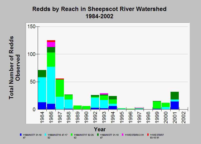
| Caption: This chart shows the number of Atlantic salmon redds observed each year during spawner surveys conducted by the Maine Atlantic Salmon Commission (ASC) in the Sheepscot River watershed for the years 1984 to 2002. The totals for each year are broken down by reach and are listed in upstream order. MS is mainstem Sheepscot and WB is West Branch Sheepscot. The highest numbers of redds were usually observed in the mainstem Sheepscot between Head Tide dam and the confluence with the West Branch Sheepscot, although this did not hold true for every year. Sampling effort was not necessarily the same in all years, and no surveys were conducted in 1985 and 1991. Choate Brook and Trout Brook were also surveyed at least once, but no redds were observed. The reach location of 7 redds in 1984 and 9 redds in 1994 were not specified in the database and so are not shown in this chart. See Info Links for more information. | |
 |
To learn more about this topic click Info Links .
To view additional information (data source, aquisition date etc.) about this page, click Metadata .
To view the table with the chart's data, click Chart Table web page.
To download the table with the chart's data, click fish_redd_sheep_asc_1984_2002_reach.db (size 18,432 bytes)
To download the table with the chart's data as an Excel spreadsheet, click fish_redd_sheep_asc_1984_2002_reach.db.xls (size 4,608 bytes) .
| www.krisweb.com |