
| Area | Basin-wide/Regional |
| Topic | Flow: Annual 7 & 30-day minima - Sheepscot at N Whitefield, 1939-2003 |
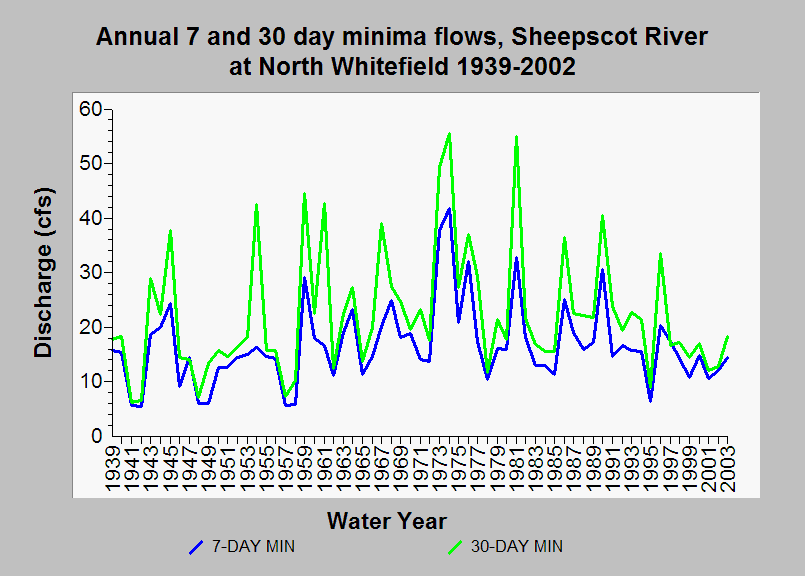
| Caption: This chart displays annual 7 and 30-day minima flows for the Sheepscot River at North Whitefield, Maine (USGS gage 01038000) between 1939 and 2002. No significant changes in low flows have been observed within the period of record (p-values 0.5 for 7 and 30 day minima, respectively). This analysis was completed by IFR-KRIS staff hydrologist and utilized daily average flow data from the USGS and the Indicators of Hydrologic Alteration (IHA) flow statistics model. See Info Links for more Information. | |
 |
To learn more about this topic click Info Links .
To view additional information (data source, aquisition date etc.) about this page, click Metadata .
To view the table with the chart's data, click Chart Table web page.
To download the table with the chart's data, click flow_stats_sheepscot_usgs01038000.dbf (size 14,549 bytes)
To download the table with the chart's data as an Excel spreadsheet, click flow_stats_sheepscot_usgs01038000.dbf.xls (size 32,922 bytes) .
| www.krisweb.com |