
| Area | Basin-wide/Regional |
| Topic | Habitat: Maximum Pool Depths in in Sheepscot Watershed 1997-1999 |
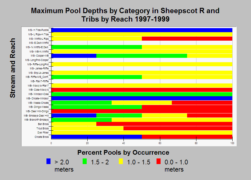
| Caption: This chart shows the maximum depth of pools measured during Atlantic salmon habitat typing surveys conducted in the Sheepscot River and its tributaries by the Maine Atlantic Salmon Commission and U.S. Fish and Wildlife Service in 1997-1999. Adult salmon need pools to hold in during the summer months. Reaches with no pools are white in the chart. Streams in the chart are grouped by stream and sorted in upstream order. See Chart Table for a key to reach names (MS is mainstem Sheepscot and WB is West Branch Sheepscot). See Info Links for more information. | |
 |
To learn more about this topic click Info Links .
To view additional information (data source, aquisition date etc.) about this page, click Metadata .
To view the table with the chart's data, click Chart Table web page.
To download the table with the chart's data, click sheep_hab_sheep_usfws_1997_1999_chart.db (size 18,432 bytes)
To download the table with the chart's data as an Excel spreadsheet, click sheep_hab_sheep_usfws_1997_1999_chart.db.xls (size 23,753 bytes) .
| www.krisweb.com |