
| Area | Basin-wide/Regional |
| Topic | Land Use: Cropland Acreage in 3 Sheepscot Counties, 1987-1997 |
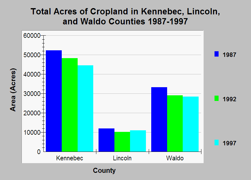
| Caption: This chart shows the total acreage of cropland in Kennebec, Lincoln, and Waldo counties during the period 1987-1997. These three counties comprise most of the Sheepscot watershed. The total acreage of cropland declined from 1987-1997, likely due to conversion of farmland to residential areas. Note that the data are for the entire extent of the each county, not just the pieces that are in the Sheepscot watershed. Data were collected by the U.S. Census of Agriculture. See Info Links for more information. | |
 |
To learn more about this topic click Info Links .
To view additional information (data source, aquisition date etc.) about this page, click Metadata .
To view the table with the chart's data, click Chart Table web page.
To download the table with the chart's data, click land_use_sheepcounties_census_87_99_chart.db (size 18,432 bytes)
To download the table with the chart's data as an Excel spreadsheet, click land_use_sheepcounties_census_87_99_chart.db.xls (size 6,144 bytes) .
| www.krisweb.com |