
| Area | Basin-wide/Regional |
| Topic | Temperature: All Sheepscot Sites, MWAT by Year 1994-2003 |
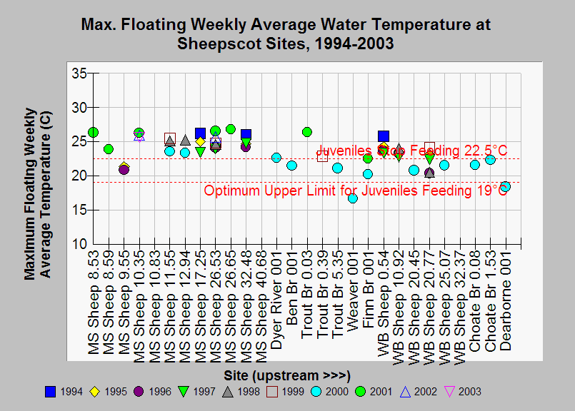
| Caption: This chart shows maximum floating weekly average temperature (MWAT) for each site in the Sheepscot River watershed with available data in the years 1994-2003. MWAT is the average of the daily average water temperatures during the warmest week of the year. Sites are grouped by stream and listed in upstream order. Tributaries are listed in the order they join their parent stream. Maximum floating weekly average temperatures exceed 22.5°C at most mainstem Sheepscot and West Branch Sheepscot sites, but not at many of the smaller tributaries. Elliott (1991) found that juvenile Atlantic Salmon stop feeding when temperatures exceed 22.5°C. Temperature data are from the Maine Atlantic Salmon Commission. See Chart Table for a key to sites and see Map for site locations. See Info Links for more information. | |
 |
To learn more about this topic click Info Links .
To view additional information (data source, aquisition date etc.) about this page, click Metadata .
To view the table with the chart's data, click Chart Table web page.
To download the table with the chart's data, click temp_sheep_asc_1994_2003_mwat_mwmt.dbf (size 15,181 bytes)
To download the table with the chart's data as an Excel spreadsheet, click temp_sheep_asc_1994_2003_mwat_mwmt.dbf.xls (size 12,803 bytes) .
| www.krisweb.com |