
| Area | Basin-wide/Regional |
| Topic | WQ: Dissolved Organic Carbon MDEP Baseflow Sites 1999-2001 |
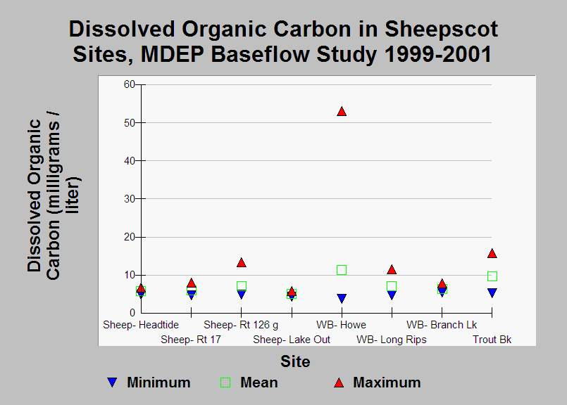
| Caption: This chart shows the minimum, mean, and maximum dissolved organic carbon (DOC) levels at 8 Sheepscot River watershed sites for the 1999-2001 data. Data were collected in June-October as part of the Maine Department of Environmental Quality's baseflow water quality sampling. With the exception of one high reading in the West Branch Sheepscot, dissolved organic carbon levels were similar at all sites, and according to Arter (2004) are in the typical range for a Maine river. | |
 |
To learn more about this topic click Info Links .
To view additional information (data source, aquisition date etc.) about this page, click Metadata .
To view the table with the chart's data, click Chart Table web page.
To download the table with the chart's data, click wq_base_bw_dep_master_99_01_summary.db (size 22,528 bytes)
To download the table with the chart's data as an Excel spreadsheet, click wq_base_bw_dep_master_99_01_summary.db.xls (size 11,764 bytes) .
| www.krisweb.com |