
| Area | Basin-wide/Regional |
| Topic | WQ: Salinity SVCA Sites 1994-2003 |
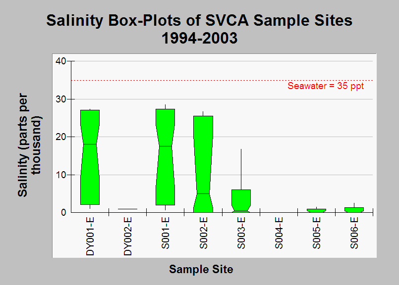
| Caption: This chart contains summary statistical data of all salinity data measurements taken at SVCA sample sites between 1994 and 2003, with units of parts per thousand. Data show that the lower Dyer River site DYOO1-E and the two lowest mainstem Sheepscot sites S001-E and S002-E have salinity concentrations not far from pure seawater. The median of the data measurements are represented by the notches, the 10th and 90th percentiles are represented by the ends of the boxes, and the 5th and 95th percentile are represented by the whiskers. See Info Links for more information. | |
 |
To learn more about this topic click Info Links .
To view additional information (data source, aquisition date etc.) about this page, click Metadata .
To view the table with the chart's data, click Chart Table web page.
To download the table with the chart's data, click wq_bw_svca_94-03_salinity_summary.db (size 18,432 bytes)
To download the table with the chart's data as an Excel spreadsheet, click wq_bw_svca_94-03_salinity_summary.db.xls (size 5,632 bytes) .
| www.krisweb.com |