
| Area | Basin-wide/Regional |
| Topic | WQ: Total Phosphorus MDEP Baseflow Sites 1999-2001 |
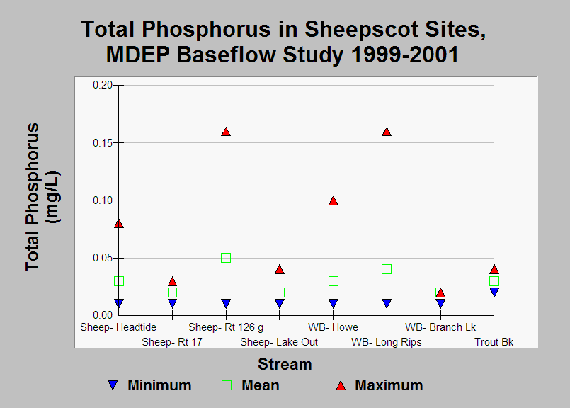
| Caption: This chart shows the minimum, mean, and maximum total phosphorus levels measured during the Maine Department of Environmental Protection WQM Program's 1999-2001 baseflow study. Data were collected in June-October. Total Phosphorus levels were highest in the West Branch Sheepscot sites and also in the mainstem Sheepscot at Route 126, about 1.75 miles below the confluence of the West Branch and mainstem Sheepscot. Rivers with more than 0.05mg/L Total Phosphorus are often negatively impacted (Arter, 2004). See Info Links for more information. | |
 |
To learn more about this topic click Info Links .
To view additional information (data source, aquisition date etc.) about this page, click Metadata .
To view the table with the chart's data, click Chart Table web page.
To download the table with the chart's data, click wq_base_bw_dep_master_99_01_summary.db (size 22,528 bytes)
To download the table with the chart's data as an Excel spreadsheet, click wq_base_bw_dep_master_99_01_summary.db.xls (size 11,764 bytes) .
| www.krisweb.com |