
| Area | Basin-wide/Regional |
| Topic | WQ: pH MDEP Baseflow, First Storm 1999 |
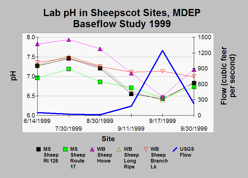
| Caption: This chart shows pH (as measured in samples at laboratory) at five Sheepscot River watershed sites during six sampling dates in summer/fall 1999, with Sheepscot stream flow at the USGS gage overlaid as a thick blue line. On September 11 the season's first rainstorm increased streamflow to 179 cubic feet per second (cfs) from 32 cfs a day earlier. At the same time, pH levels decreased substantially at all sites except the mainstem Sheepscot at Route 17 (above the confluence with the West Branch). By September 30, streamflow had diminished and pH had increased back to near baseflow levels. Data were collected as part of the Maine Department of Environmental Quality's baseflow water quality sampling. | |
 |
To learn more about this topic click Info Links .
To view additional information (data source, aquisition date etc.) about this page, click Metadata .
To view the table with the chart's data, click Chart Table web page.
To download the table with the chart's data, click wq_bw_dep_1999_ph_details.db (size 18,432 bytes)
To download the table with the chart's data as an Excel spreadsheet, click wq_bw_dep_1999_ph_details.db.xls (size 4,608 bytes) .
| www.krisweb.com |