
| Area | Mainstem Sheepscot |
| Topic | WQ: pH by Hour, Sheepscot River above Head Tide (RKm10.35) 2001-2003 |
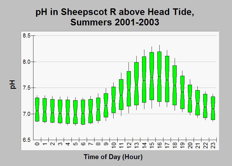
| Caption: This chart shows a summary of pH data in the Sheepscot River above Head Tide (river kilometer 10.35) from July, August, and September for the years 2001-2003, shown by time of day (hour). Data were collected by NOAA Fisheries using an automated probe and were corrected (see Source Table for additional details on correction). pH values show substantial diurnal fluctuations, with lowest values in the early morning hours, and highest values in the late afternoon. These diurnal fluctuations are likely due to photosynthetic activity. The median of the data measurements are represented by the notches, the 10th and 90th percentiles are represented by the ends of the boxes, and the 5th and 95th percentile are represented by the whiskers. NOAA Fisheries provided this disclaimer for the data: "DATA APPROXIMATIONS - date were collected by NOAA-Fisheries Northeast Fishery Science Center but processed previous to full implementation of 'Section 515 Pre-Dissemination Review and Documentation Guidelines' data have been audited by J. Hawkes, but THESE DATA SHOULD BE CONSIDERED APPROXIMATIONS for more information contact J. Hawkes at 207-866-7109." See Info Links for more information. | |
 |
To learn more about this topic click Info Links .
To view additional information (data source, aquisition date etc.) about this page, click Metadata .
To view the table with the chart's data, click Chart Table web page.
To download the table with the chart's data, click wq_datasonde_sheep_noaa_2001_2003_ph_time.db (size 18,432 bytes)
To download the table with the chart's data as an Excel spreadsheet, click wq_datasonde_sheep_noaa_2001_2003_ph_time.db.xls (size 10,752 bytes) .
| www.krisweb.com |