
| Area | Upper Sheepscot |
| Topic | Fish: Electrofishing - Salmon Density in Sheep. R at Hwy 17 1968-2001 |
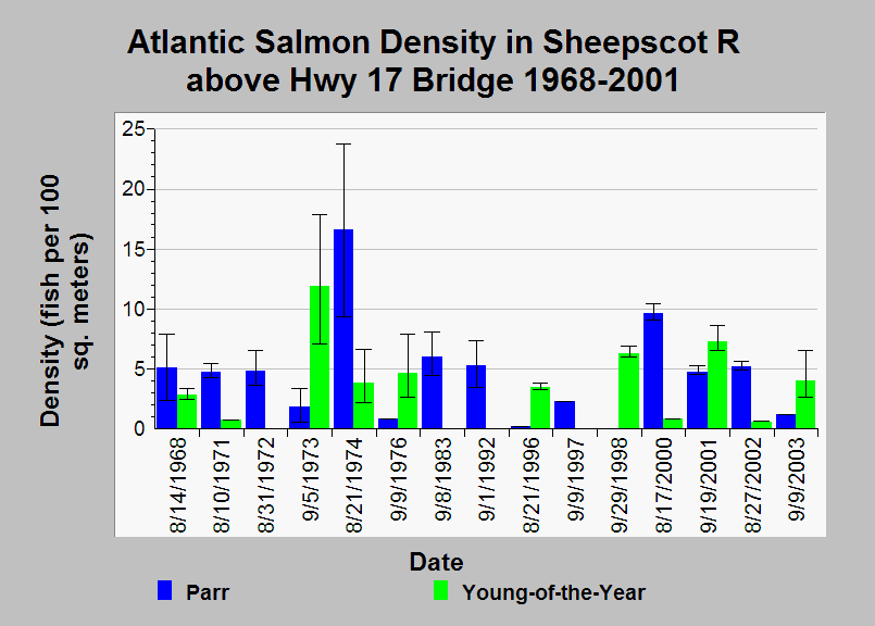
| Caption: This Chart shows Atlantic salmon densities calculated from electrofishing surveys in the Sheepscot River upstream of the Highway 17 Bridge (river kilometer 32.48) from 1968 to 2001. The colored bars in the chart are point estimates and error-bars represent the 95% confidence limits. The Maine Atlantic Salmon Commission (ASC) assembled the data and calculated density estimates. See Info Links for more information. | |
 |
To learn more about this topic click Info Links .
To view additional information (data source, aquisition date etc.) about this page, click Metadata .
To view the table with the chart's data, click Chart Table web page.
To download the table with the chart's data, click fish_efish_sheep_asc_58_03_density_11mainst32.48.db (size 18,432 bytes)
To download the table with the chart's data as an Excel spreadsheet, click fish_efish_sheep_asc_58_03_density_11mainst32.48.db.xls (size 11,100 bytes) .
| www.krisweb.com |