
| Area | Upper Sheepscot |
| Topic | WQ: Total Phosphorus in Upper Sheepscot Lakes |
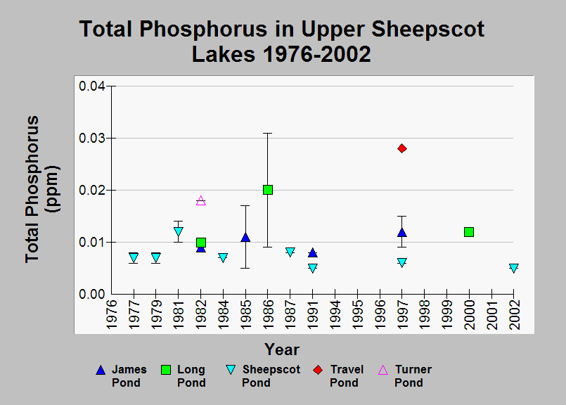
| Caption: This chart shows mean total phosphorus levels in Upper Sheepscot lakes sampled in the Maine Volunteer Lake Monitoring Program. The error bars show the standard error and represent the variability of multiple samples taken in the same year. Data were collected for the period of 1976-2002. These data were collected as discrete samples through the and in some cases only one sample was collected per year and sampling often happened between July and September. The highest phosphorus level was observed in Travel Pond during sampling in 1997. Generally, phosphorus levels showed small fluctuation between years with the largest variability seen in Long pond (0.01 ppm in 1982 and 0.02 ppm in 1986). See Info Links for more information. | |
 |
To learn more about this topic click Info Links .
To view additional information (data source, aquisition date etc.) about this page, click Metadata .
To view the table with the chart's data, click Chart Table web page.
To download the table with the chart's data, click wq_bw_lakes_pearl_tp_76-02.xls_summary.db (size 6,144 bytes)
To download the table with the chart's data as an Excel spreadsheet, click wq_bw_lakes_pearl_tp_76-02.xls_summary.db.xls (size 5,120 bytes) .
| www.krisweb.com |