
| Area | West Branch Sheepscot |
| Topic | Habitat: Woody Debris in WB Sheepscot Sub-basin 1997-1999 |
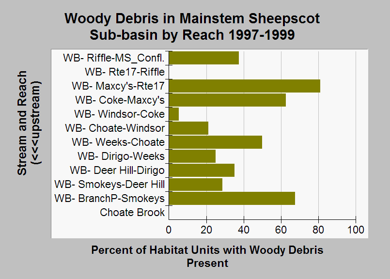
| Caption: This chart shows the percentage of habitat units in each reach where surveyors noted the presence of woody debris. Surveys were conducted in the Mainstem Sheepscot sub-basin during 1997-1999 by the Maine Atlantic Salmon Commission and U.S. Fish and Wildlife Service. Habitat units where surveyors did not note whether or not woody debris was present were excluded from this calculation. Streams in the chart are grouped by stream and sorted in upstream order. See Chart Table for a key to reach names (MS is mainstem Sheepscot and WB is West Branch Sheepscot). See Info Links for more information. | |
 |
To learn more about this topic click Info Links .
To view additional information (data source, aquisition date etc.) about this page, click Metadata .
To view the table with the chart's data, click Chart Table web page.
To download the table with the chart's data, click sheep_hab_ws_usfws_1997_1999_chart.db (size 18,432 bytes)
To download the table with the chart's data as an Excel spreadsheet, click sheep_hab_ws_usfws_1997_1999_chart.db.xls (size 13,741 bytes) .
| www.krisweb.com |