Bibliography Background About KRIS
Roads and Erosion
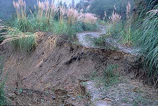
Road failures can contribute both fine and course sediment to streams, and accumulated road failures in large storm events can have catastrophic effects, such as filling in pools and reducing habitat complexity. Studies show that roads can contribute 50 to 80% of the sediment that enters streams (Hagans et al., 1986). The amount of sediment delivered from forests with roads can be more than 300 times greater than from undisturbed forest land (Morrison, 1975). Roads on ranch lands and those leading to rural and suburban parcels may also contribute to sediment problems in a watershed.
Surface erosion from roads can produce chronic sources of fine sediment which can diminish salmon and steelhead spawning success (Cedarholm et al., 1981). Roads constructed next to streams are chronic contributors of fine sediment, particularly if they are used in winter months. Winter logging exacerbates this problem because the truck wheels pump fines from within the road bed to the surface. Fine sediment from roads that enters streams fills interstitial spaces in gravel streambeds, reducing survival of salmon and steelhead eggs and aquatic insects.
Cedarholm et al. (1980) found that fine sediment in salmon spawning gravels increased by 2.6 - 4.3 times in watersheds with more than 4.1 miles of roads per square mile of land area. Matthews (1999) linked increased road densities to increased sediment yield in the Noyo River. Regional studies from the interior Columbia River basin (Haynes et al., 1996) show that bull trout do not occur in watersheds with more than 1.7 miles of road per square mile (see figure below) and NOAA (1995) set limits for road densities on National Forest lands in the Columbia River Basin at no more than 2.5 mi./sq. mi. The National Marine Fisheries Service (1996) guidelines for salmon habitat characterize watersheds with road densities greater than 3 miles of road per square mile of watershed area (mi/sq mi) as "not properly functioning", while "properly functioning condition" was defined as less than or equal to 2 mi./sq. mi., with no or few stream aide roads.
 Based on extensive field data analysis of road densities and the occurrence of bull trout the USFS characterizes road density levels of greater than 1.7 mi./sq. mi. as High and greater than 4.7 mi./sq. mi. as Extremely High, as indicated in this figure, from Haynes et al. (1996).
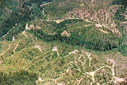
Road density calculations often include only main haul roads not skid trails and spur roads, which also contribute to erosion. The network of skid trails shown at left in this photograph would not be counted in road density calculations, but they do increase risk of surface erosion. In some cases, they become pathways followed by sediment directly into water courses.
Road failures can be triggered by several different mechanisms:
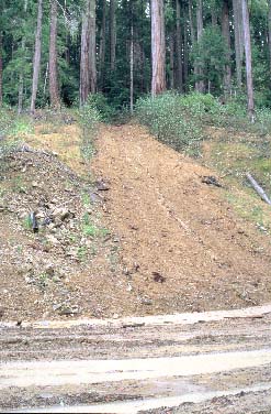
- Side Cast Material: When roads are being constructed, material excavated from the road bed is often side-cast off the edge of the road. This mound of material perched on a steep slope can become saturated and trigger a landslide that may take the road bed with it.
- Fill and Cut-Bank Failures: Forest roads are often built across weakly consolidated soils. If the road bed is not properly compacted and armored with a layer of rock, the road bed itself may fail as it becomes saturated. The exposed soil of a road cut can become saturated during a large storm event and trigger a landslide that takes out the road as well.
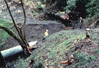
- Plugged Culvert: Each time a logging road crosses a stream, culverts are used to funnel the water under the road. The culvert is buried with fill material so that the logging road remains fairly level at the stream crossing. When culverts get plugged in large storm events, water backs up behind them and can take out the road. This type road failure is a human-induced debris torrent which contributes large amounts of sediment to the stream. If there are road crossings downstream from a culvert failure, they too will fail as the debris torrent extends down stream.
- Headwall or Mid-Slope Failure: When roads are constructed across steep headwater areas or across mid-slope areas with emergent ground water, they often fail. The compaction associated with road construction and use can block the flow of shallow ground water. This ground water pushes up near the surface and can saturate the road prism that in turn increases its likelihood of failure. Roads in headwater or mid-slope locations are often constructed on steep slopes and failures initiate debris torrents that can cause significant destruction.
 |
 |
 |
|---|---|---|
| Typical road failure in northern California watershed, Elk River watershed, Humboldt County. | Typical road failure in northern California watershed, Elk River watershed, Humboldt County | When this culvert became plugged, water washed the fill downhill. Photo taken at Redwood National Park |
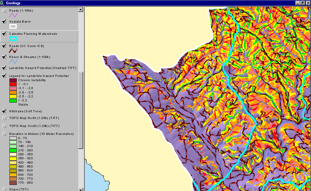 This map shows the main haul road network associated with logging activities in the Little North Fork Gualala River, lower North Fork and the western part of the Robinson Creek drainage. In addition, landslide risk from the Shallow Landslide Stability Model (SHALSTAB) is shown. The latter demonstrates that some roads are crossing areas of the landscape with a high risk of shallow debris torrents, which could effect subsequent failures and sediment yield (see Background page on SHALSTAB).
From KRIS Gualala Map project (154 KB)
Because road-drainage crossings can be the largest categorical source of sediment within watersheds, cost-effective inventory and prioritization methods should be employed in all watersheds where roads and erosion are of concern (Weaver and Hagans, 1994; Flanagan et al. 1998). Road decommissioning has been shown to be an effective means of reducing sediment to salmon streams (Harr and Nichols, 1993). Taylor and Love (2003) recognize that culverts at road crossings may also be barriers to anadromous fish adults and juveniles, but they also present solutions to this problem.
References
Cedarholm, C.J., L.M. Reid and E.O. Salo. 1981. Cumulative effects of logging road sediment on salmonid populations of the Clearwater River, Jefferson County, Washington. Pages 38-74 in Proceedings of Conference on Salmon Spawning Gravel: A Renewable Resource in the Pacific Northwest? Report 19. Wash. State University, Water Research Center, Pullman, WA.
Flanagan, S.A., M.J. Furniss, T.S. Ledwith, M.A. Love, K. Moore, and J. Ory. 1998. Methods for inventory and environmental risk assessment of road drainage crossings. Water/Road Interaction Technology Series. 9877 1809-SDTDC. USDA Forest Service, Technology and Development Program. San Dimas, CA. 52 pp.
Hagans, D.K., W.E. Weaver and M.A. Madej. 1986. Long term on-site and off-site effects of logging and erosion in the Redwood Creek basin, Northern California. In: Papers presented at the American Geophysical Union meeting on cumulative effects (1985 December); National Council on Air and Streams, Tech.Bull.No. 490, pp.38-66.
Harr, R.D. and R.A. Nichols. 1993. Stabilizing Forest Roads to Help Restore Fish Habitats: A Northwest Washington Example. Fisheries 18(4): 18-22.
Matthews, Graham and Associates. 1999. Sediment Source Analysis and Preliminary Sediment Budget for the Noyo River. Prepared for: Tetra Tech,Inc. under contract 68-C7-0018, work assignment # 0-18. Matthews Assoc., Weaverville, CA.
Morrison, P.H. 1975. Ecological and Geomorphological Consequences of Mass Movements in the Alder Creek Watershed and Implications for Forest Land Management. B.A. Thesis. University of Oregon, Eugene, OR. 102 p.
National Marine Fisheries Service (NMFS) 1995. Endangered Species Act Section 7 Biological Opinion on the Land and Resource Management Plans for the Boise, Challis, Nez Perce, Payette, Salmon, Sawtooth, Umatilla, and Wallowa-Whitman National Forests. Memo to USFS Regional Foresters on March 1, 1995. NMFS, National Oceanic and Atmospheric Administration, Northwest Region, Seattle, WA. 138 p.
National Marine Fisheries Service (NMFS) 1996. Coastal Salmon Conservation: Working Guidance for Comprehensive Salmon Restoration Initiatives on the Pacific Coast. September 1996. 5pp. [139kb]
Taylor, R. N. and M. Love. 2003. California salmonid stream habitat restoration manual, "Part IX: Fish passage evaluation at stream crossings". California Department of Fish and Game. 100 pp. [4.5Mb]
Weaver, W.E., and D.K. Hagans. 1994. Handbook for Forest and Ranch Roads - A Guide for Planning, Designing, Constructing, Reconstructing, Maintaining and Closing Wildland Roads. Prepared for the Mendocino County Resource Conservation District, Ukiah, California. 161 pp.