Pool Frequency and Depth
in Battle Creek

Pools are important for
various life stages of salmon, steelhead and resident trout and disturbance
to the landscape can cause loss of pool habitat and limit fisheries productivity.
The Battle Creek Watershed Assessment (WA) (Terraqua, 2004) measured
the frequency of pools and residual pool depth following Aquatic and Riparian
Effectiveness Monitoring Program (AREMP) protocols (Gallo, 2002) (see note on
methods). These two measures were used as an indication
of suitability for salmonids according to the Ecosystem Management Decision
Support (EMDS) criteria (Reynolds, 2001).
The U.S. Forest Service
(Armentrout et al., 1998) studied Deer, Antelope and Mill creeks, immediately
to the south of the Battle Creek watershed, and noted that low gradient reaches
tended to be subject to pool filling and fines accumulation and, therefore,
sensitive to sediment increases. They defined pool depths of greater than 3.3
feet as suitable for juvenile salmonid rearing.
Findings of Battle
Creek Watershed Assessment
Battle Creek watershed
pool frequency and depth was analyzed by Terraqua (2004):
- "Scour pools were
characterized at 50 sample sites in the watershed. Additionally, non-scour
formed pools (e.g., wood- or bedrock-controlled pools) were characterized
at 38 of 50 sample sites. Scour pools made up 76 percent of the total pools
at the 38 sites where scour and non-scour pools were both assessed.
- All pools were further
characterized as occurring in anadromous or non-anadromous habitats. Of the
191 pools observed; sixty three (33%) were located in the 17 sample sites
occurring in anadromous habitats, and 128 pools (67%) occurred in the 33 non-anadromous
sample sites. Pools occurred at about the same rate for anadromous (3.7 pools/site)
and non-anadromous (3.9 pools/site) sites.
- Pool frequency (based
on scour pools only) was described at 49 sample sites as the number of scour
pools per 100 meters of stream. Among all sites within the Battle Creek watershed,
the mean pool frequency was 1.7 scour pools per 100 meters of stream while
pool frequency at individual sites ranged from 0 to 6.9 scour pools per 100
meters of stream.
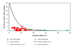
- Pool frequency decreased
significantly with increasing bankfull width (F-test; p = 0.02; Figure 10)
although this relationship is notable for its weakness (small coefficient
of determination, r2 = 0.18; and small regression coefficient, b=-0.06) and
for the fact that pool frequency was not lognormally distributed, as was expected."

|
This
chart from the Battle Creek WA shows the distribution of scour pools
versus the expected log-normal relationship with channel width, which is
how the EMDS pool frequency rating curve is calculated. The green dots indicate
sites where scour pool frequency is "fully favorable" for salmonids,
red dots show sites where pool frequency was "fully unfavorable",
and light red is "likely unfavorable". Taken from Figure
10 in the Battle Creek WA. |

|
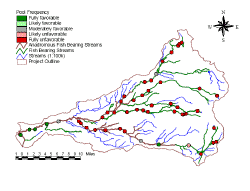
The
Battle Creek WA shows a map of scour pool frequency at all sites
measured in 2001 and 2002 with EMDS criteria displayed as color codes with
green indicating "fully favorable" salmonid habitat and red "fully
unfavorable" conditions. The only reaches with fully favorable pool
frequency for salmonids are four within lower Battle Creek and one on the
South Fork above Panther Creek. Partially favorable habitats are shown
in gray and pink. Taken from Figure 11 in the Battle Creek WA. |

|
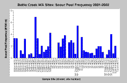
This
chart shows the raw data for scour pool frequency per 100 meters,
which were collected as part of the Battle Creek WA. The highest
unweighted pool frequencies were on the mainstem of Battle Creek above Coleman
Hatchery and at sites on U.S. Forest Service lands in Nannie Creek and upper
South Fork Digger Creek. Note that several sites had no scour pools. Chart
from KRIS Battle Creek V 2.0. |
Terraqua (2004) characterized
pools 3 feet deep or more as suitable for anadromous fish but pools 3 feet to
10 feet deep as optimal for over-summer holding of adult salmon. Pools 1 foot
deep or more were characterized as "fully favorable" for resident
trout. The Battle Creek WA had the following findings regarding pool
depths:
- "The mean pool
depth in habitat accessible to anadromous salmonids was 0.92 meters, and the
maximum observed pool depth was 2.46 meters. At sites accessible to anadromous
salmonids, 60 percent of the pools were considered fully unfavorable (depths
< 1.0 meter) for adult spring Chinook salmon holding. We found 25 pools
fully favorable for adult spring Chinook holding within the 5,168 meters of
habitat accessible to anadromous salmonids that we surveyed.
- The mean residual pool
depth at sites not accessible to anadromous salmonids was 0.4 meters, and
the maximum depth observed was 2.3 meters. At sites not accessible to anadromous
salmonids, 40 percent of the pools were considered fully unfavorable (depth
< 0.3 meters) for adult trout production."

|
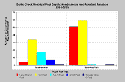
The
chart at left shows the frequency of occurrence of pools by depth at all
Battle Creek WA sites. Pools in resident trout reaches were less
than the 1 foot deep criteria ("fully unfavorable") at 40% of
sites measured and 60% of pools at sites accessible to anadromous fish were
less than three feet deep, making them "fully unfavorable". Chart
from KRIS Battle Creek V 2.0. |
The Battle Creek WA
(Terraqua, 2004) drew the following conclusions about pool frequency and depth
in Battle Creek:
- "Pool frequencies
and depths were lower at middle and high elevation sites than predicted though
pool frequencies had increased or remained the same since 1988. Approximately
150 pools with depths greater than 1 meter would be suitable as spring Chinook
salmon adult holding habitat although very few of these pools are greater
than 2 meters deep....
- Residual pool depth
was significantly correlated with elevation (negatively), watershed area (positively),
stream gradient (negatively), and the proportion of the watershed in rain-on-snow
area (negatively)....
- Model exploration confirmed
that road density, near-stream road density, road-stream crossings, proportion
of watershed in rhyolite soils, and forest cover play no meaningful role in
predicting variability in observed residual pool depth data."
The Battle Creek WA also
found a relationship between decreased residual pool depth and area of the watershed
at elevations susceptible to rain-on-snow effects.

References
Armentrout,
S., H. Brown, S. Chappell, M. Everett-Brown, J. Fites, J. Forbes, M. McFarland,
J. Riley, K. Roby, A. Villalovos, R. Walden, D. Watts, and M.R. Williams, 1998.
Watershed Analysis for Mill, Deer, and Antelope Creeks. U.S. Department of Agriculture.
Lassen National Forest. Almanor Ranger District. Chester, CA. 299 pp. [6.0 Mb]
Gallo,
K. 2002. Field protocols: Aquatic and Riparian Effectiveness Monitoring
Program for the Northwest Forest Plan: Version 1.0. U.S. Forest Service, Corvallis,
OR. 54 pp. [125 Kb]
Reynolds,
Keith M. 2001. Fuzzy logic knowledge bases in integrated landscape assessment:
examples and possibilities. Gen. Tech. Rep. PNW- GTR-521. Portland, OR: U.S.
Department of Agriculture, Forest Service, Pacific Northwest Research Station.
24 p.
Terraqua,
Inc. 2004. Battle Creek Watershed Assessment :Characterization of stream
conditions and an investigation of sediment source factors in 2001 and 2002.
Performed under contract to the Battle Creek Watershed Conservancy, Manton,
CA. Funds from the Anadromous Fisheries Restoration Program and U.S. Fish and
Wildlife Service under Agreement DCN: 11330-1-J113.


![]()
![]()
![]()