 |
||
![]()
Terraqua (2004) measured large woody debris (LWD) in Battle Creek using Aquatic and Riparian Effectiveness Monitoring Program (AREMP) protocols (Gallo, 2002) compatible with the EMDS model (Reynolds, 2001) for analysis in the Battle Creek Watershed Assessment (WA). Riparian conditions can have bearing on large wood recruitment, and discussions of Sierra Nevada ecosystem riparian conditions are included in the references (Kondolf et al., 1996). Similarly, the California Department of Fish and Game memo (Fisk et al., 1966) about Battle Creek channel and riparian conditions after the 1964 flood is available as relevant background information.
Findings of Battle Creek Watershed Assessment
The Battle Creek WA used methods similar to Gallo (2002) and below are summarized findings regarding large wood at all sites:
"Large woody debris frequency was quantified at 48 sample sites. Large woody debris frequency ranged from 0 to 458 pieces per 1,000 meter of stream and averaged 97 pieces per 1,000 meter. EMDS analysis indicates, with reasonable or high certainty, that wood conditions at 25 of 48 sites were fully or likely favorable for salmonid production, while wood conditions at 7 sites were fully or likely unfavorable. Large woody debris conditions at the remaining sites were moderately favorable."
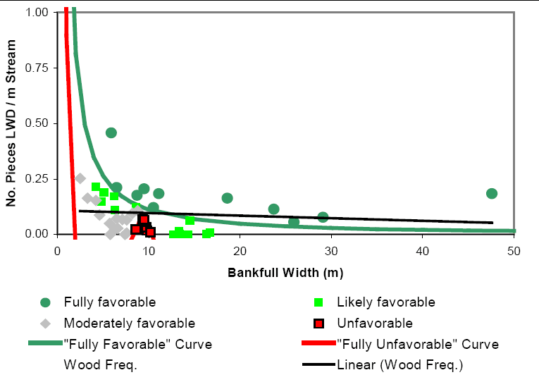 |
This frequency distribution curve, based on EMDS ratings for large woody debris, is from the Battle Creek WA. Red dots show the"fully unfavorable for salmonid production" ratings at seven sites, green dots the "fully favorable" rating sites, and gray dots indicate "moderately favorable" levels of large wood. Terraqua (2004) explained the distribution of moderately favorable locations in the unfavorable areas of the curve as follows: "This odd relationship in the EMDS model, where the 'unfavorable curve' is expressed as a function of the standard error associated with a relationship between wood and bankfull width described by Bilby and Ward (1991), casts doubt on the interpretation of these sites as 'unfavorable'." |
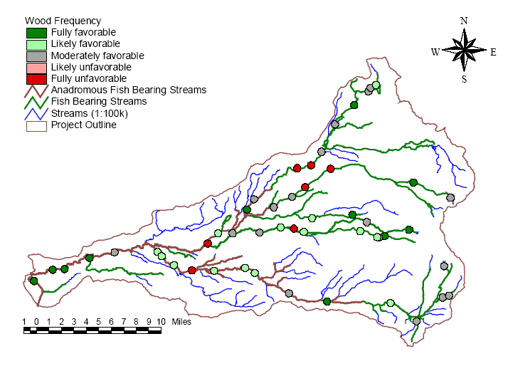 |
The map at left shows large wood levels in stream channels as interpreted by the EMDS model for various reaches of Battle Creek as taken from the Battle Creek WA. It shows seven locations as fully unfavorable with regard to large wood - two on the mainstem North Fork below Manzanita Creek, two on Bailey Creek, two in Digger Creek and one in the lower South Fork Battle Creek. "EMDS analysis indicates, with reasonable or high certainty, that wood conditions at 25 of 48 sites were fully or likely favorable for salmonid production while wood conditions at 7 sites were fully or likely unfavorable. Large woody debris conditions at the remaining sites were moderately favorable" Terraqua (2004). |
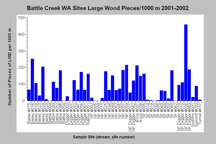 |
This chart shows large wood per 1,000 m of stream at all Battle Creek WA sites, but does not take into account stream width as EMDS rating curves do. This chart shows the whole range of wood values by locations, which vary from 0 to 458. Chart from KRIS Battle Creek V 2.0. |
|
Related
Pages
|
|
| Battle Creek Overview | KRIS General Background |
|
The Importance of Large Wood in Streams and Problems of Depletion |
|
![]()
References
Bilby, R. E., and J. W. Ward. 1989. Changes in characteristics and function of woody debris with increasing size of streams in western Washington. Transactions of the American Fisheries Society 118: 368-378.
Fisk, L., E. Gerstung, and R. Hansen. 1966. Stream damage surveys - 1966. Inland Fisheries Administrative Report No. 66-10. California Department of Fish and Game. Sacramento, CA. 14 pp. [162kb]**
Gallo, K. 2002. Field protocols: Aquatic and Riparian Effectiveness Monitoring Program for the Northwest Forest Plan: Version 1.0. U.S. Forest Service, Corvallis, OR. 54 pp. [125 Kb]
Kondolf, G. M., R. Kattelmann, M. Embury, and D.C. Erman, 1996. Status of riparian habitat. Chapter 36 of Sierra Nevada Ecosystem Project: Final report to Congress. Vol. II, Assessments and scientific basis for management options. University of California, Centers for Water and Wildland Resources. Davis, CA. 22 pp. [1.4Mb]
Reynolds, Keith M. 2001. Fuzzy logic knowledge bases in integrated landscape assessment: examples and possibilities. Gen. Tech. Rep. PNW- GTR-521. Portland, OR: U.S. Department of Agriculture, Forest Service, Pacific Northwest Research Station. 24 p.
Terraqua, Inc., 2004. Battle Creek Watershed Assessment: Characterization of stream conditions and an investigation of sediment source factors in 2001 and 2002. Terraqua, Inc. for the Battle Creek Watershed Conservancy. Wauconda, WA. Funds from the Anadromous Fisheries Restoration Program and U.S. Fish and Wildlife Service under Agreement DCN: 11330-1-J113 78 pp. [2.0Mb]
| www.krisweb.com |