 |
Battle Creek Overview | Bibliography | Home | |
Using Battle Creek Vegetation Data as an Index of Watershed Disturbance
![]()
Terraqua (2004) used vegetation data to discern potential relationships of timber harvest timber to aquatic habitat conditions collected for the Battle Creek Watershed Assessment (WA) because no electronic timber harvest maps were available for use in analysis. Kier Associates (2003) acquired vegetation data derived from Landsat TM data classified by the U.S. Forest Service (USFS) (warbington et al., 1998) and the California Department of Forestry (CDF) and provided it to Terraqua along with assistance in analysis. A summary of Battle Creek WA findings regarding vegetation data and aquatic habitat conditions are presented below.
Beardsley et al. (1996) used data generated as part of the University of California's Sierra Nevada Ecosystem project and found that only 8% of old growth coniferous trees in the region remained and that: "less than 2 percent of the 3 million acres of privately owned coniferous forests was old growth." They used trees of 40 inches in diameter as an index for old growth forests in the region.
Landscape vegetation data for California has been derived from TM Landsat imagery by the USFS (Warbington et al., 1998). CDF's Fire and Resource Assessment Program (FRAP) and USFS Spatial Analysis Lab use Landsat data from different years to compare changes in vegetation, known as change scene detection (Levien et al., 2002). Levien et al. (2002) studied northeastern California data, including the Battle Creek watershed, for changes in vegetation comparing 1991 and 1996 and found that decreased ground cover came predominantly on private lands while areas of forest growth came more on public land. "The Sierran mixed conifer class exhibits the largest change of all conifer types with a decrease in cover on 237,869 acres (8%)" (Levien et al., 2002). Most National Forests had more tree growth than decrease but "the Lassen National Forest has the largest acreage of conifer cover decrease at 44,393 acres."
Findings of Battle Creek Watershed Assessment
The Battle Creek Watershed Assessment used vegetation type and tree size data based 30 meter resolution Thematic Mapper (TM) 1996 Landsat imagery classified by the U.S. Forest Service Spatial Analysis Lab and provided by Kier Associates (2003). Terraqua (2004) chose to use tree diameters of greater than 20 inches in diameter at breast height (dbh) on a one hectare scale as an indication of mid-seral conditions and forest cover, as described below:
"For this analysis, we considered trees larger than 20 inches as indicating mid- to late-seral conditions. This size class break was the closest approximation within the USFS vegetation data to the 24 inches size class break chosen by Keithley (1999). Keithley (1999) characterized trees from 24- to 36 inches in diameter as mid-seral and those greater than 36 inches as late-seral."
Forest cover as defined by presence of trees of 20 inch basal height diameter (dbh) or greater constituted only 10% of the Battle Creek watershed and the sub-basins above Battle Creek WA aquatic monitoring sites had an average of 20% (range 6% to 56%) cover composed of trees of this size or greater. Terraqua (2004) found no relationship between their index for forest cover and channel conditions.
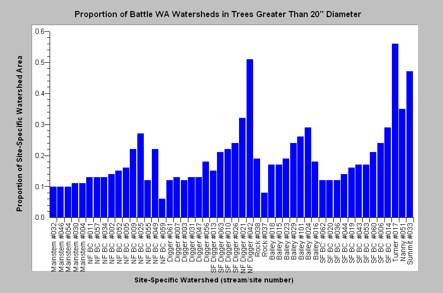 |
Terraqua (2004), with assistance from Kier Associates (2003) used USFS and CDF vegetation data derived from a 1996 Landsat image to estimate forest cover. This chart shows the percentage of watershed areas above Battle Creek Watershed Assessment aquatic monitoring sites that are covered in trees greater than 20 inches in diameter. From KRIS Battle Creek Version 2.0. |
|
Related
Pages
|
|
| Battle Creek Overview | KRIS General Background |
|
|
|
![]()
References
Armentrout, S., H. Brown, S. Chappell, M. Everett-Brown, J. Fites, J. Forbes, M. McFarland, J. Riley, K. Roby, A. Villalovos, R. Walden, D. Watts, and M.R. Williams, 1998. Watershed Analysis for Mill, Deer, and Antelope Creeks. U.S. Department of Agriculture. Lassen National Forest. Almanor Ranger District. Chester, CA. 299 pp. [6.0 Mb]
Beardsley, D., C. Bolsinger, and R. Warbington. 1999. Old-growth forests in the Sierra Nevada: by type in 1945 and 1993 and ownership in 1993. Res. Pap. PNW RP-516. Portland, OR: U.S. Department of Agriculture, Forest Service, Pacific Northwest Research Station. 46 p.
Kier Associates. 2003. Use of Spatial Data for Battle Creek Watershed Conditions Assessment. Produced for use of Terraqua, Inc. for the Battle Creek Watershed Assessment. 37 p. [10 Mb]
Keithley, C. 1999. Evaluating Stream and Watershed Conditions in Northern California. Prepared for the California Department of Forestry, Fire and Resource Assessment Program. Sacramento, CA. 17 pp.
Kondolf, M.G., R. Kettlemann, M. Embury, and D.C. Erman. 1996. Status of Riparian Habitat. In Sierra Nevada Ecosystem Project: Final report to Congress. Vol. 36. University of California at Davis, Centers for Water and Wildland Resources. 22 p.
Levien, L., C. Fischer, P. Roffers, B. Maurizi, and J. Suero. 2002. Monitoring Land Cover Changes in California Northeastern California Project Area. Cooperative venture of USDA Forest Service Spatial Analysis Lab and California Department of Forestry Fire and Resource Assessment Program, Sacramento.
Warbington, R., B. Schwind, C. Curlis and S. Daniel. 1998. Creating a Consistent and Standardized Vegetation Database for Northwest Forest Plan Monitoring in California. USDA Forest Service. Pacific Southwest Region Remote Sensing Lab. Sacramento, CA.
![]()
| www.krisweb.com |