 |
Battle Creek Overview | Bibliography | Home | |
![]()
Trees growing adjacent to streams, or in the wetland zone associated with streams, are part of the riparian zone. Forest health conditions within this zone are recognized as having a profound influence on the diversity and health of the adjoined aquatic habitat. The Battle Creek Watershed Assessment (Terraqua, 2004) utilized riparian information from a 1996 TM Landsat image in a limited way as an index of grazing. Lack of accuracy of electronic U.S. Geologic Survey 1:100,000 hydrologic data (see note) prevented more extensive use for quantitative riparian assessment.
Sierra Nevada studies by the U.S. Forest Service (Beardsley et al., 1996) provide information on regional historic forest conditions, including riparian areas. Kondolf et al. (1996) noted that timber harvest and associated near-stream road construction had detrimental effects on potential for large wood recruitment to adjacent streams, and that riparian damage can also occur from bedload movement associated with cumulative watershed effects. The California Department of Fish and Game (Fisk et al., 1966) described riparian and channel conditions in reaches and tributaries of the North Fork Battle Creek after the 1964 flood.
|
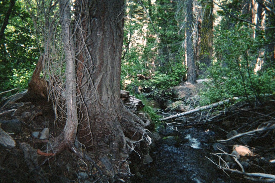
A large
conifer in the upper reaches of the North Fork Digger Creek on U.S. Forest
Service lands (at left) appears to be approaching or exceeding 40 inches.
This stand may approximate baseline conditions for riparian, at least at
this elevation in the watershed. Photo from Terraqua (2004) site #042.
|
|
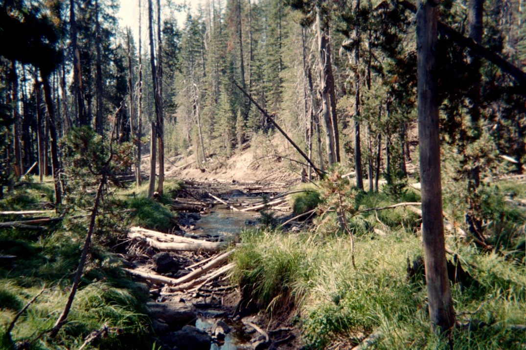
The riparian zone of the upper North Fork Battle Creek near the upper influence of the North Fork Battle Creek Reservoir (at left), has mostly small diameter trees, with average breast height diameter at this site mostly under 20 inches. It appears that lake levels may cause periodic flooding, which could be linked to tree mortality at this site. Photo from Terraqua (2004) at site #059. |
|
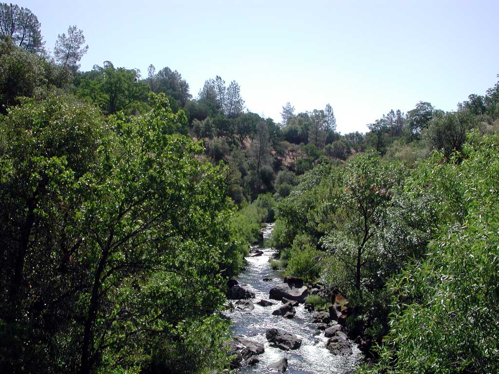
The lower
North Fork Battle Creek in is shown in Blue Oak Woodlands, where riparian
trees would have naturally smaller average basal diameter than reaches at
higher elevation in the Sierran Mixed Conifer zone. Riparian zones
also have less influence on stream temperatures in lower reaches, where
the channel is usually wider and not as easily shaded by streamside trees.
Photo by Pat Higgins from KRIS Battle Creek Version 2.0.
|
Findings of Battle Creek Watershed Assessment
The Battle Creek WA used areas of Non-Forest and Saplings (< 5" diameter at breast height) as defined by Landsat vegetation data (Warbinginton et al, 1998) in 100 meter riparian stream buffers to define meadow areas, which were then used as a surrogate for grazing impacts:
"The USFS vegetation data, as described above in 'Forest Cover', were also used to identify near-stream meadow areas. The 'near-stream' area was defined as above in 'Near- Stream Road Density.' Areas characterized as meadows included all areas predominated by vegetation less 5 inches in diameter."
Near stream roads, within 100 meters of the stream on both sides of the channel, were considered a potential upland sediment source (Terraqua, 2004), but not as an index of riparian health.
The Battle Creek WA found that:
"Approximately 25 percent of all near-stream areas within the Battle Creek watershed are vegetated with vegetation smaller than 5 inches in diameter. On average, 18 percent (± 9 SEM; range 0 to 50) of each of 51 site-specific near-stream areas were vegetated with vegetation smaller than 5 inches in diameter."
The Battle Creek WA found a relationship between near-stream meadows and residual pool depth: "The positive association between residual pool depth and near-stream meadow area (i.e., pools with greater residual depths are more likely to be found in watersheds with a greater proportion of riparian areas in small trees, shrubs or grass) is counter intuitive and difficult to explain." Their discussion of this finding follows:
"One possible explanation for the observed relationship of deeper pools in site-specific watersheds with greater near-stream meadow areas is that most of the sites with high near-stream meadow areas were located in sparsely-treed, low elevation portions of the watershed (e.g., the mainstem Battle Creek, lower North Fork Battle Creek and lower South Fork Battle Creek) where pools were deeper and where near-stream areas are topographically protected from livestock grazing. Steep canyon walls typically exclude cattle from these areas. On the other hand, grazing does seem to occur throughout even the higher-elevation, forested areas of the watershed where we tended to find shallow pools. The link between near-stream meadow area and elevation was particularly clear in our observation of collinearity between elevation and near-stream meadow area both variables were so tightly covariant that they exhibited similar power in explaining variability in residual pool depth."
|
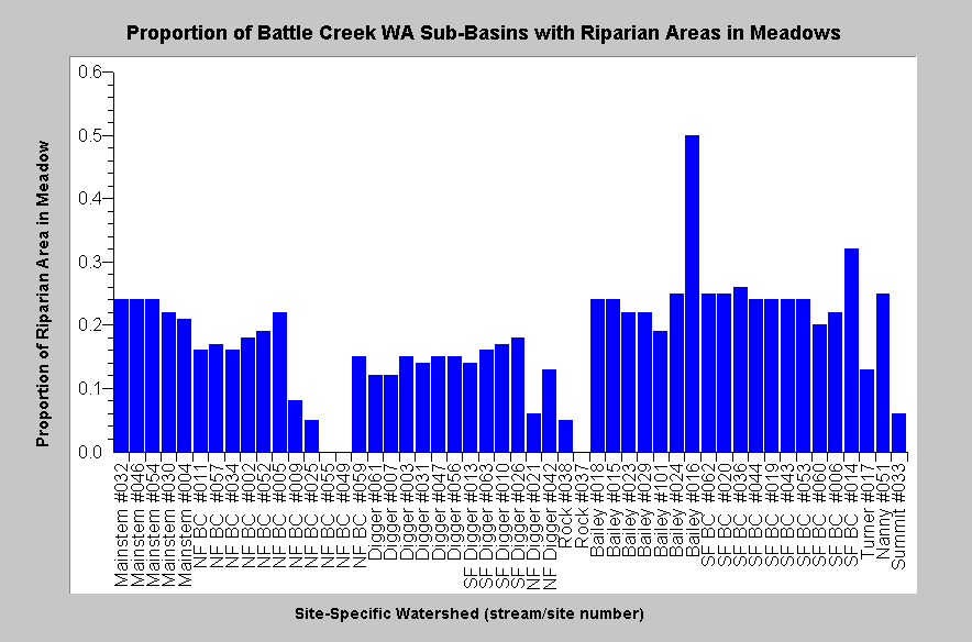
The proportion of riparian zones in watersheds above Battle Creek WA aquatic monitoring sites with Non-Forest or Sapling (<5" dbh) is displayed at left and indicates that Upper Bailey Creek has the highest near-stream meadow areas followed by the upper South Fork below Battle Creek Meadows. Chart from KRIS Battle Creek Version 2.0 |
|
Related
Pages
|
|
| Battle Creek Overview | KRIS General Background |
![]()
References
Armentrout, S., H. Brown, S. Chappell, M. Everett-Brown, J. Fites, J. Forbes, M. McFarland, J. Riley, K. Roby, A. Villalovos, R. Walden, D. Watts, and M.R. Williams, 1998. Watershed Analysis for Mill, Deer, and Antelope Creeks. U.S. Department of Agriculture. Lassen National Forest. Almanor Ranger District. Chester, CA. 299 pp. [6.0 Mb]
Beardsley, D., C. Bolsinger, and R. Warbington, 1999. Old-growth forests in the Sierra Nevada: by type in 1945 and 1993 and ownership in 1993. Res. Pap. PNW-RP-516. U.S. Department of Agriculture, Forest Service. Pacific Northwest Research Station. Portland, OR. 46 pp. [1.25Mb]
Fisk, L., E. Gerstung, and R. Hansen. 1966. Stream damage surveys - 1966. Inland Fisheries Administrative Report No. 66-10. California Department of Fish and Game. Sacramento, CA. 14 pp.
Kondolf, G. M., R. Kattelmann, M. Embury, and D.C. Erman, 1996. Status of riparian habitat. Chapter 36 of Sierra Nevada Ecosystem Project: Final report to Congress. Vol. II, Assessments and scientific basis for management options. University of California, Centers for Water and Wildland Resources. Davis, CA. 22 pp. [1.4Mb]
Terraqua, Inc., 2004. Battle Creek Watershed Assessment: Characterization of stream conditions and an investigation of sediment source factors in 2001 and 2002. Terraqua, Inc. for the Battle Creek Watershed Conservancy. Wauconda, WA. Funds from the Anadromous Fisheries Restoration Program and U.S. Fish and Wildlife Service under Agreement DCN: 11330-1-J113 78 pp. [2.0Mb]
Warbington, R., B. Schwind, C. Curlis and S. Daniel. 1998. Creating a Consistent and Standardized Vegetation Database for Northwest Forest Plan Monitoring in California. USDA Forest Service. Pacific Southwest Region Remote Sensing Lab. Sacramento, CA.
![]()
| www.krisweb.com |