
| Area | Basin-wide |
| Topic | Vegetation: Forest Cover (Trees > 20" dbh) above Battle WA Sites |
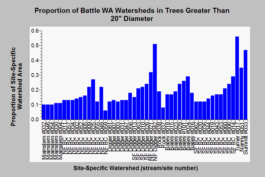
| Caption: Terraqua (2004) used USFS and CDF vegetation data derived from a 1996 Landsat image to estimate forest cover. This chart shows the percentage of watershed areas above Battle Creek Watershed Assessment aquatic monitoring sites that are covered in trees greater than 20 inches in diameter. Watersheds of tributaries on U.S. Forest Service lands, such as upper North Fork Digger, Turner, Summit and Nanny Creeks, have the largest components of trees in this size class. Terraqua (2004) found no relationship between "forest cover" and sediment in streams using a power analysis. See Info Links for more information. | |
 |
To learn more about this topic click Info Links .
To view additional information (data source, aquisition date etc.) about this page, click Metadata .
To view the table with the chart's data, click Chart Table web page.
To download the table with the chart's data, click mikes_res_corr_stats.dbf (size 11,288 bytes)
To download the table with the chart's data as an Excel spreadsheet, click mikes_res_corr_stats.dbf.xls (size 19,592 bytes) .
| www.krisweb.com |