
| Area | Mainstem Battle |
| Topic | Sediment: Percent Fines <2 mm at Main Battle WA Sites 2001-2002 |
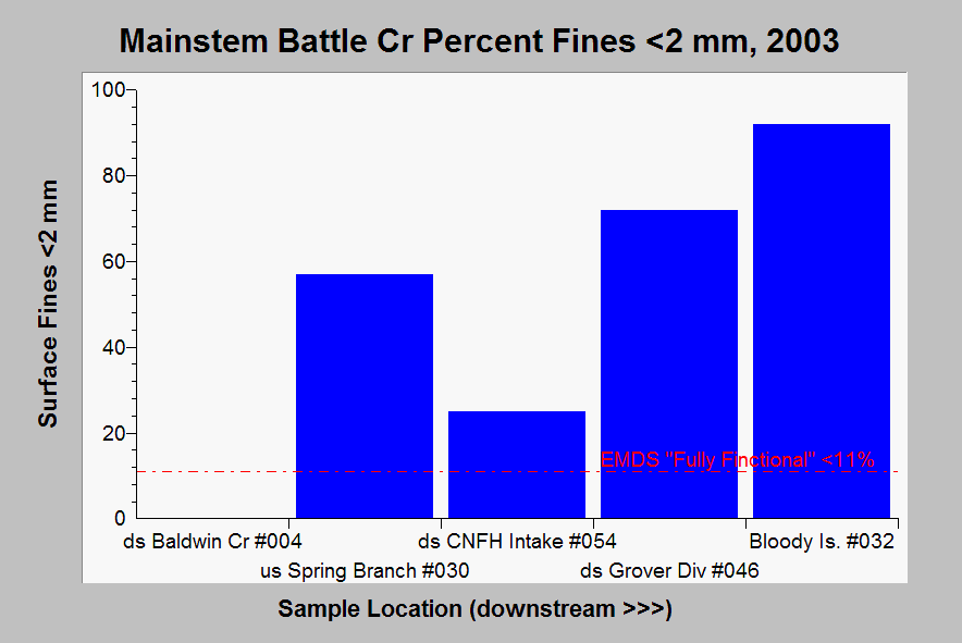
| Caption: This chart shows surface fine sediment (<2 mm) from lower mainstem Battle Creek Watershed Assessment sites based on data collected in 2001-2002 with the EMDS reference value for "fully functional" salmonid habitat of less than 11%. Light blue bars signify that all sites are in response reaches. Site #004 was not sampled for fines. Fines increase in a downstream direction from site #054 to #032, which is corollary to the decreasing D50 values and suggests recent sediment supply, possibly from the January 1997 storm. Abbreviations are ds = downstream and ab = above. Data from Terraqua (2004). See Info Links for more information. | |
 |
To learn more about this topic click Info Links .
To view additional information (data source, aquisition date etc.) about this page, click Metadata .
To view the table with the chart's data, click Chart Table web page.
To download the table with the chart's data, click emds_mward_battle_mainstem_2003.dbf (size 3,284 bytes)
To download the table with the chart's data as an Excel spreadsheet, click emds_mward_battle_mainstem_2003.dbf.xls (size 10,752 bytes) .
| www.krisweb.com |