
| Area | North Fork Battle |
| Topic | Sediment: Percent Fines <2 mm at Bailey Cr Battle WA Sites |
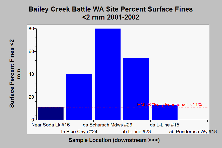
| Caption: This chart shows surface fine sediment (<2 mm) from pool tail crests at Battle Creek Watershed Assessment samples sites in Bailey Creek in 2001-2002. Light blue response reaches (#024, #029, #023), except the site downstream of the L-Line Road were well over "fully functional" levels recognized by EMDS of 12.5%. The response reach (dark blue) near Soda Lake had surface fines within the EMDS fully functional range. No measurement was taken at site #018. All sample locations are in non-anadromous reaches. Abbreviations are ds = downstream and ab = above. Some locations could not be measured for fine sediment because rooted aquatic plants were growing in the substrate of pool tail crests. Data from Terraqua (2004). See Info Links for more information. | |
 |
To learn more about this topic click Info Links .
To view additional information (data source, aquisition date etc.) about this page, click Metadata .
To view the table with the chart's data, click Chart Table web page.
To download the table with the chart's data, click emds_mward_bailey_2003.dbf (size 3,710 bytes)
To download the table with the chart's data as an Excel spreadsheet, click emds_mward_bailey_2003.dbf.xls (size 10,240 bytes) .
| www.krisweb.com |