
| Area | North Fork Battle |
| Topic | Sediment: Percent Fines <2 mm at NF & SF Digger Cr Battle WA Sites |
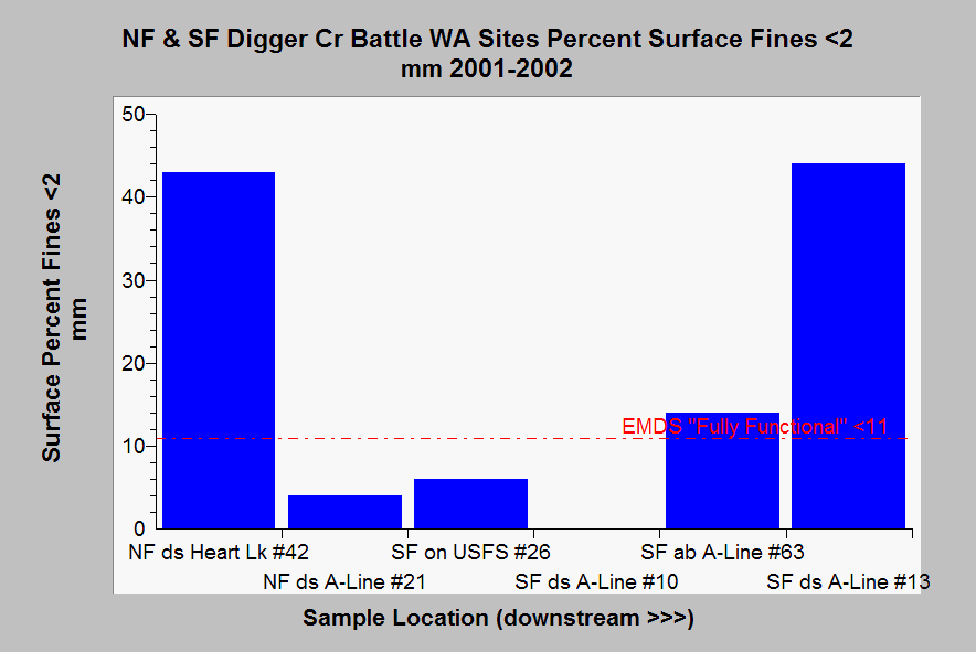
| Caption: This chart shows surface fine sediment (<2 mm) from pool tail crests at Battle Creek Watershed Assessment samples sites along the North Fork and South Fork Digger Creek in 2001-2002. Most sites are in response reaches (light blue), and the only transport reach (site #10) was not measured for fine sediment. Fines were at or near optimal EMDS levels at three sites but higher at two others. Abbreviations are ds = downstream and ab = above. Fine sediment at South Fork sites appears to increase in a downstream direction. Some locations could not be measured for fine sediment because rooted aquatic plants were growing in the substrate of pool tail crests. Data from Terraqua (2004). See Info Links for more information. | |
 |
To learn more about this topic click Info Links .
To view additional information (data source, aquisition date etc.) about this page, click Metadata .
To view the table with the chart's data, click Chart Table web page.
To download the table with the chart's data, click emds_mward_digger_forks_2003.dbf (size 3,602 bytes)
To download the table with the chart's data as an Excel spreadsheet, click emds_mward_digger_forks_2003.dbf.xls (size 10,752 bytes) .
| www.krisweb.com |