Bibliography Background About KRIS
Hypothesis #2: Coho salmon production is limited by high water temperature in some reaches of the Big River.
Support for Hypothesis From the Literature
Two recent studies conducted in northern California found that coho salmon were at extremely low abundance or absent in streams where the floating weekly average water temperature exceeded 16.80 Celsius one or more times during the season (Welsh et al.(2001); Hines and Ambrose, 1998). Welsh et al. (2001) measured stream temperatures in the Mattole River and its tributaries while Hines and Ambrose (1998) studied numerous streams in the holdings of the Georgia Pacific Company (now Hawthorne Timber Company), including tributaries of the Big River. Welsh et al. (2001) called the maximum of all floating weekly average temperatures the maximum weekly average temperature or MWAT. This is not to be confused with the temperature stress threshold for salmonid species described by Armor (1990). See the Temperature background page for more information. Lewis et al. (2000) pointed out that lower-river temperatures are elevated as a result of being further from their spring sources and that water temperatures in interior basins were more subject to warming than those in the fog zone. Poole and Berman (2000) found that removal of trees next to the stream and in the overstory further back in the riparian zone can open air flow and elevate water temperatures.
Supporting Data Topics in KRIS Big River Maps and Database
Maahs (1999) documented local efforts to implement pond rearing programs for coho and chinook salmon juveniles in 1974 but found “water temperatures in Big River reached as high as 78o F and remained 70o F or more for much of July and August”. (Maahs, 1999). California Department of Fish and Game noted that coho salmon inhabited the entire length of the South Fork Big River (1958d) and most of Daugherty Creek (1959b). Morehouse (CDFG, 1959b) measured the water temperature of Daugherty Creek during an August 1959 survey and found temperatures ranged between 58 and 62 degrees Fahrenheit (14.4-16.7o C), which would be consistent with coho being present in surveyed reaches. Recent measurements show that floating weekly water temperatures in Daugherty Creek now consistently exceed 16.8 C, and fish samples typically lack coho salmon (see Hypothesis #1).
Many timber harvests have been permitted along Daugherty Creek, and riparian conditions indicate very small-diameter trees. These conditions are shown below using information from the KRIS Big River Map project. Morehouse (1959b) characterized the riparian zone of Daugherty Creek: "The section of stream from the mouth of Snuffins Creek downstream to just above the mouth of John Gates Creek is well shaded by the forest cover which lines the stream banks. The majority of this section is seemingly through virgin forest. The remainder of this stream, from the mouth of John Gates Creek, downstream to the mouth is well shaded." It appears that opening air flow over Daugherty Creek, as a result of timber harvest, has increased heat exchange during warm summer days and made lower Daugherty Creek uninhabitable for coho.
Water temperatures in the lower Big River and South Fork Big River are also displayed, but high water temperatures in those locations are a result of cumulative heating in reaches upstream as well as local riparian conditions. While stream width makes these higher order streams somewhat more subject to warming (Lewis, 2000), old growth redwoods 200 feet high would provide shade to most reaches of the Big River, and would have promoted a cooler microclimate over the stream before human disturbance.
The charts below are derived from the Topics listed here. Check these Topics in the KRIS database to see the information in context and to access the Info Links and Metadata.
(DC) Temperature: Floating Weekly Average, Daugherty Creek 1995-97 & 2000
(LB) Temperature: Floating Weekly Average of Big River below SF 1993-96, 98
(SF) Temperature: Floating Weekly Average of SF Big River 1996-97,1999,2000
(NF) Temperature: Floating Weekly Average East Branch NF Big River
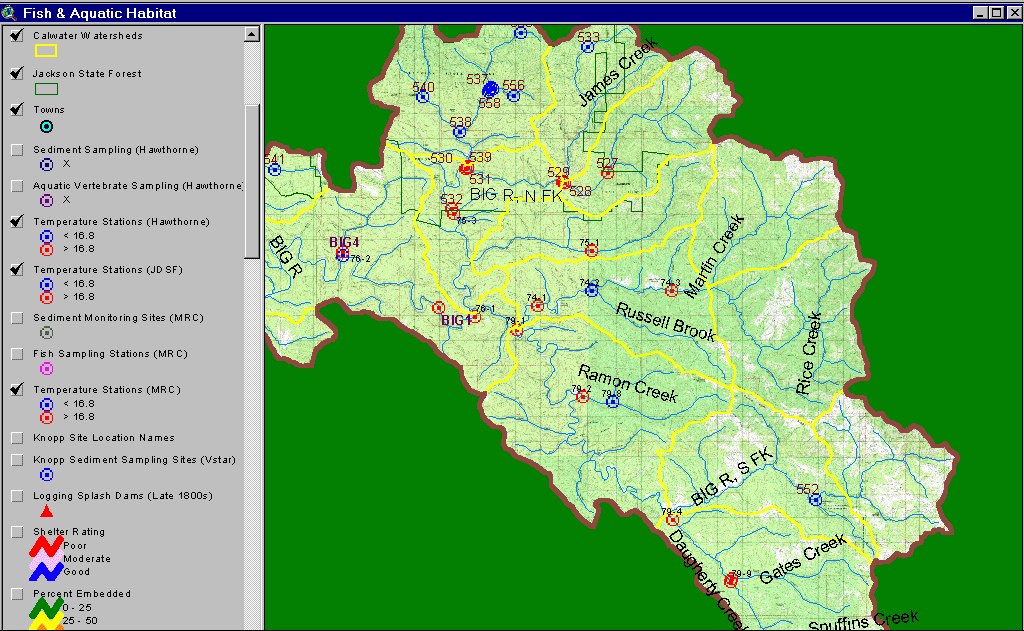 This image, from the KRIS Big River Map project, shows the location of all temperature data collection stations with coding as to whether temperatures at the sites exceeded a maximum weekly floating average temperature of 16.8° C in any year measured. Mainstem reaches of the Big River are chronically over temperatures likely to support coho in some or all years measured.
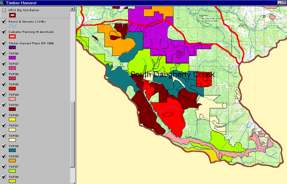 The image at right shows timber harvests in Daugherty Creek (South Daugherty Calwater) between 1986 and 1999. Timber harvests were filed specifically for the riparian zone of Daugherty Creek above Gates Creek and harvests below that point include riparian areas. Timber harvests may have retained direct shade canopy as mitigation, but allowed considerable removal of large diameter trees. Data provided by the California Department of Forestry.
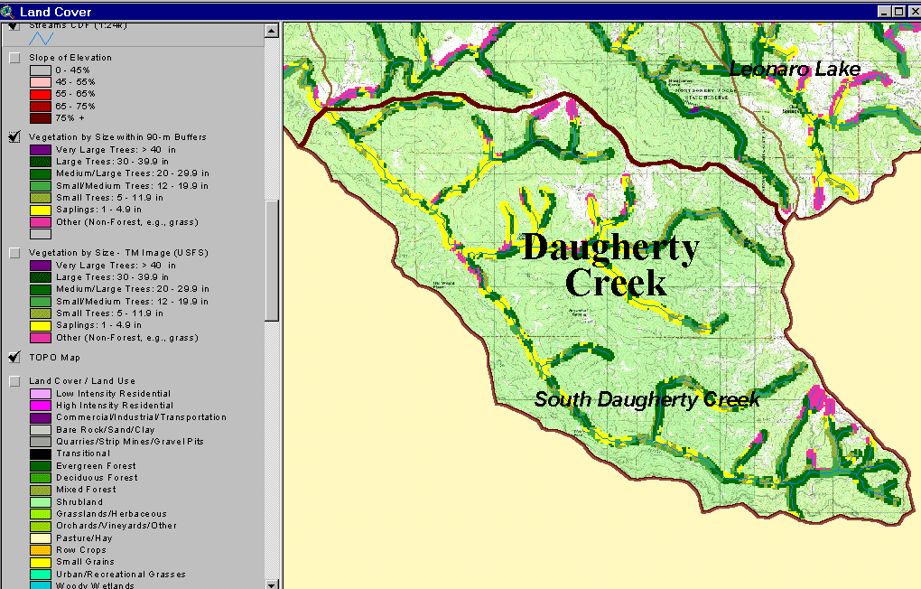 The image at left, from the KRIS Big River Map project, shows USFS vegetation and stand types for the riparian zone (90 meter buffer) of Daugherty Creek, derived from a 1994 Landsat image. Non-Forest and Saplings in the riparian zone are mostly associated with recent timber harvest. The scale of accuracy for stands is one hectare. Early seral stands in the riparian zone open air flow over the stream and make Daugherty Creek subject to warming.
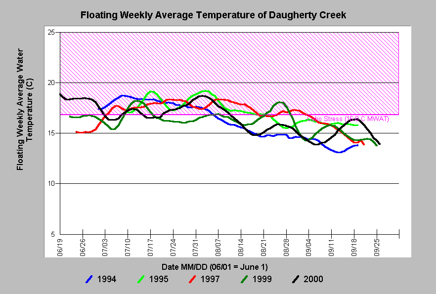 This chart shows the floating weekly average water temperature of Daugherty Creek at its convergence with the South Fork in 1994, 1995, 1997, 1999 and 2000. All years exceeded the MWAT of 16.8 degrees, indicating that coho salmon production in this reach is limited by temperature. Data from Mendocino Redwood Company.
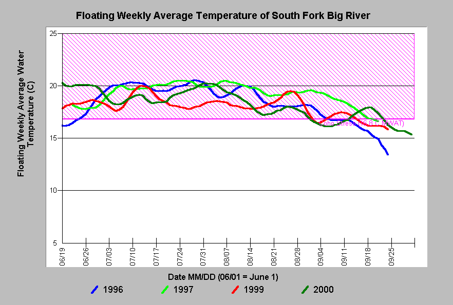 The floating weekly average water temperature of the South Fork Big River above the North Fork exceeded the 16.8 degrees C threshold for coho stress in 1996, 1997, 1999 and 2000. This reach is temperature limited with regard to coho salmon production. Warming is a result of poor riparian conditions on the South Fork itself as well as cumulative warming in upstream reaches. Data from Mendocino Redwood Company.
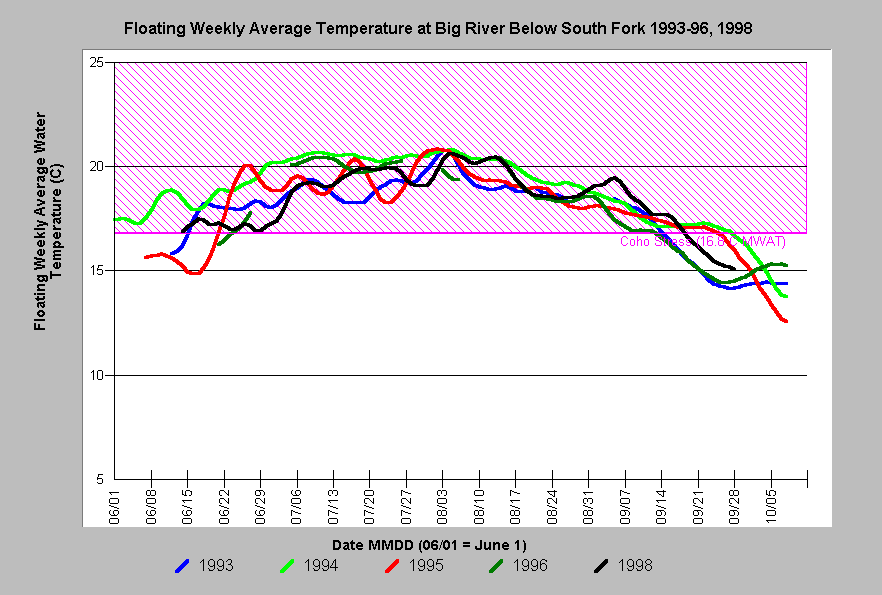 The chart at right shows that the lower Big River, below the South Fork, exceeded temperature levels suitable for coho salmon juveniles ( 16.8 degrees C MWAT) in all years measured. Problems in this reach are partially the result of cumulative warming in reaches upstream.
Alternative Hypothesis
Many reaches of the Big River were always warm and coho never predominated there.
Ambrose and Hines (1997) advance this alternative hypothesis for the mainstem reaches of the nearby Ten Mile River, asserting that warming may be caused by channel width, orientation and bedrock type. There is little ability to gauge the historic range of Big River stream temperatures, so this hypothesis is impossible to fully test.
Monitoring Trends to Support or Refute the Hypothesis
While this hypothesis has been supported by field data in the Big River basin (Hines and Ambrose, 1998), it could be further explored with more field studies to confirm or refute the relationships, as canopy in the basin recovers and width-to-depth ratios improve. The latter would be a result of erosion control measures decreasing sediment supply and allowing channel recovery.
References
Ambrose, J., and D. Hines. 1997. Ten Mile River Watershed 1996 Instream Monitoring Results. Georgia-Pacific West Inc. Fort Bragg, CA. 55 pp.
Armour, C.L. 1991. Guidance for evaluating and recommending temperature regimes to protect fish. U.S. Fish and Wildlife Service. Fort Collins. Biological Report 90(22). 13 p.
California Department of Fish and Game (CDFG). 1958d. South Fork Big River (Big River tributary) stream survey, 8 August 1957 and/or 8 November 1958. CDFG unpublished file memo by R.F. Elwell. Yountville, CA. 5 pp.
California Department of Fish and Game (CDFG). 1959b. Daugherty Creek (South Fork Big River tributary) stream survey, 10 August 1959. CDFG unpublished file memo by J. Morehouse. Yountville, CA. 6 pp.
Hines, D.H. and J.M. Ambrose. 1998. Evaluation of Stream Temperature Thresholds Based on Coho Salmon (Oncorhynchus kisutch) Presence and Absence in Managed Forest Lands in Coastal Mendocino County, California. Georgia Pacific Corporation, Ft. Bragg, CA. 14 p plus Appendices.
Welsh, H.H., G.R. Hodgson, M.F. Roche, B.C. Harvey. (2001). Distribution of Juvenile Coho Salmon (Oncorhynchus kisutch) in Relation to Water Temperature in Tributaries of a Northern California Watershed Determining Management Thresholds for an Impaired Cold-water Adapted Fauna. In review for publication in the North American Journal of Fisheries Management. 21:464-470, 2001.