Bibliography Background About KRIS
Hypothesis #4: High levels of sediment in Big River and its tributaries have caused habitat changes which limit coho salmon and steelhead production.
Support for Hypothesis: From the Literature
McNeil and Ahnell (1964) pointed out that excessive sediment can limit salmonid reproduction and survival (see the Sediment background page). Chapman (1988) also recognized the damaging effects of fine sediment in salmonid nests but stated that not enough experiments had been conducted to measure conditions within redds. McHenry et al. (1994) built artificial redds in Olympic Peninsula streams and placed coho salmon and steelhead eggs in them. They found that: "when fine sediments (<0.85 mm) exceeded 13%, salmonid survival dropped drastically. This suggests the existence of a threshold over which survival is very low." Although some fine sediment is removed when the female coho digs the redd, particles less than 0.85 mm are highly mobile and may re-enter the redd, even during moderate flows, if they are at very high levels in the stream bed (Beschta and Jackson, 1979).
Barnard (1992) measured fine sediment less than 1 mm in Freshwater Creek, a tributary of Humboldt Bay, inside and outside coho salmon redds and found an average of 7.5% inside and 13.1% outside. Freshwater Creek has very unstable soil types but the watershed had at least 40 to 50 years of rest from logging prior to measurements in 1988. Kondolf (2000) surveyed the literature averaged the data from ten studies and found 50% egg and alevin mortality in salmon redds when sand sized particles (< 6.4 mm) comprise 30% of the stream bed. These studies are consistent with a 14% target for fine sediment <0.85mm and 30% target for 6.4 mm set by the regional TMDL studies such as for the Garcia River (US EPA, 1998).
Barnard and McBain (1994) note that gravel permeability, dissolved oxygen, and gravel particle size composition are substrate parameters affecting the survival of incubating salmonid embryos. Tagart (1976) and McCuddin (1977) independently derived survival estimates for coho and chinook salmon based on permeability of gravels within which eggs were deposited. Less permeable gravels had lower survival rates. McBain and Trush (2000) found low permeabilities on the Garcia River but could not show strong correlations to fine sediment in gravels, and concluded that much larger gravel and permeability samples needed to be taken to increase confidence in results.
Habitat typing surveys visually estimate embeddedness of potential spawning gravels (McCain et al., 1990) and the California Department of Fish and Game (1998) has characterized good spawning substrate as less than 25% embedded.
Excessive sediment may also reduce pool volume and frequency, potentially reducing the survival of coho salmon which use pools as rearing habitat. CDFG (1998) characterized streams with greater than 40% pool frequency as being healthy salmonid habitat. Murphy et al. (1984) found pool frequencies of 39-67% in undisturbed streams. Brown et al. (1994) noted the importance of having pools deeper than a meter (39 inches) for coho juvenile rearing, and stated that loss of pools was a principal cause for loss of coho salmon in northwestern California. Reeves (1988) also found that yearling and older juvenile rainbow trout needed pools three feet deep for rearing. Boydstun (1977) noted that steelhead adults returning to the Gualala River had spent two years growing in freshwater and two years in the ocean.
If there is insufficient rearing habitat to support older age steelhead, recruitment into the adult population will subsequently decrease. Recent surveys of the Noyo River (Gallagher, 2001) estimated an adult population of steelhead of only 304-418. This contrasts with Noyo River steelhead estimates of 8,000 in the 1960's (Taylor, 1978). Noyo habitat typing also revealed low pool frequency and few pools greater than three feet deep (see KRIS Noyo).
Reeves et al. (1993) found that widespread timber harvest activity, comprising greater than 25% of a watershed's area, tended to aggrade Oregon coastal streams, fill in pools and restrict salmonid habitat diversity. Conversely, those basins harvested less than 25% maintained diverse aquatic habitat and salmonid communities.
From Big River Data
The Big River is recognized as impaired with regard to sediment under section 303d of the Clean Water Act and a Big River Total Maximum Daily Load for Sediment (US EPA, 2001) has been prepared. The report states that: "The primary adverse impacts associated with excessive sediment in the Big River pertain to the anadromous salmonid fishery. The water quality conditions do not adequately support several anadromous salmonid species present in the Big River and its tributaries, which has contributed to severe population declines." Those findings are consistent with other data showing that levels of fine sediment in gravels are over thresholds for optimal coho and steelhead egg and alevin survival, and that rearing habitat quality is also limiting..
Hawthorne Timber Company (HTC) has limited holdings in the Big River basin but has maintained two sediment sampling locations on the Little North Fork and Two Log Creek. The McNeil samples were processed by the wet-sieve method and are thus comparable to TMDL thresholds, which recognize 14% fines smaller than 0.85 mm as limiting to salmonids (US EPA, 2001).
Mendocino Redwood Company has collected Big River gravel samples and permeability data at five locations following methods similar to McBain and Trush (2000). Permeability at some MRC Big River monitoring locations indicates low egg and alevin survival when interpreted using relationships derived by Tagart (1976) and McCuddin (1977). Gravel samples from MRC are dry sieve and samples from Daugherty Creek show high levels of sand and fine gravel (<5.6 mm). Three of four sites exceeded 30% in 2000. This level of fine sediment is recognized as impairing salmonid survival (Kondolf, 2000; U.S. EPA, 2001).
Habitat typing surveys by the California Department of Fish and Game and Georgia Pacific (now Hawthorne Timber Company) are useful for understanding sediment impacts to fish habitat. High embeddedness in the Big River suggest that spawning habitat quality is low. Most locations show little habitat with less than 25% embeddedness. Pool frequency is low and there are few pools over three feet in depth, both indicators that sediment is limiting salmonid rearing habitat. Knopp (1993) used V* to measure pool volume and found a relationship between intensity of watershed management and V* scores. Big River V* results fall within the range of moderate impairment.
Matthews and Associates (2001) performed a preliminary sediment budget for the Big River which shows episodic waves of sediment related to land management since 1952. Their report shows a recent increase following the period of intense land use activity since 1985, which included extensive timber harvest and associated road construction. Matthews and Assoc. (2001) findings of increased sediment supply is consistent with information from the channel in habitat typing results.
Source Topics: The charts below are derived from the Topics listed here. Check these Topics in the KRIS database to see information in context and to have access to Info Links and Metadata.
(LB) Sediment: Fines <0.85 mm for Little North Fork (BIG 8), 1996-2001
(SF) Sediment: Fines <5.6mm from Daugherty Creek 2000
(SF) Sediment: Gravel Permeability from Daugherty Creek 2000
(BG) Sediment: Matthews Suspended Sediment and Bedload Calculations
(SF) Habitat: Habitat Types by Percent Length for All SF Streams
(BG) Habitat: Basinwide Maximum Pool Depths
(BG) Sediment: V* from 24 Streams in Mendocino County, 1992
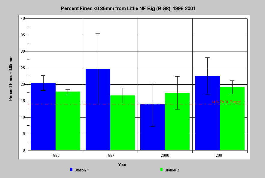 The chart at left displays percent fine sediment less than 0.85 mm from wet sieve McNeil bulk gravel samples in the Little North Fork Big River (BIG8) for 1996, 1997, 2000 and 2001. The bars represent the average of four McNeil samples at each station and the whiskers are one standard deviation from the mean. Generally, percent fines <0.85mm exceeded the Big TMDL value of 14% (U.S. EPA, 2001) at both sites in all years except 2000, when one site was under. The high range of fine sediment values (>20%) suggests that spawning success is limited at this site. Data from Hawthorne Timber Company.
 Average values for percent fine sediment less than 5.6 mm ranged from 19% to 45% for all sites in Daugherty. These proportions of sand and small gravel are much higher than optimal for salmonid egg and alevin survival. The reference of 30% is associated the Big River TMDL (U.S. EPA, 2001) and is recognized as a level that restricts salmonid egg and alevin survival. While the TMDL uses a break point of 6.4 mm, MRC gives information as 5.6 mm, which would tend to underestimate the value somewhat. MRC used the dry sieving method, so the KRIS team applied the Shirazi and Seim (1979) conversion factor to the TMDL reference of 30%, and arrived at the comparable reference of 26% for dry sieve samples.
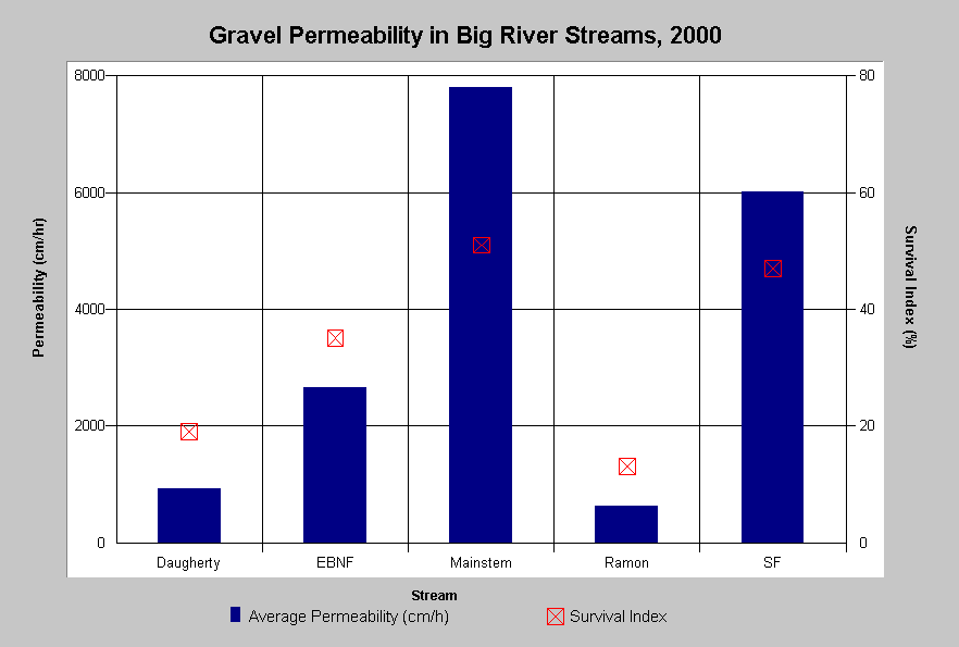 This chart displays gravel permeability from five Big River stream segments in 2000 and the associated index of salmonid emergence and survival. Permeabilities range from 629 cm/hr in Ramon Creek to 7797 cm/hr at the best location on the mainstem Big River. Expected survival of salmonid eggs in Ramon and Daugherty creeks were 13% and 19%, respectively. Although the relationship between permeability and salmonid egg and alevin survival has not been field checked in northwestern California, the very low permeability at some locations is a clear indication of impaired spawning habitat. Data from Mendocino Redwood Company.
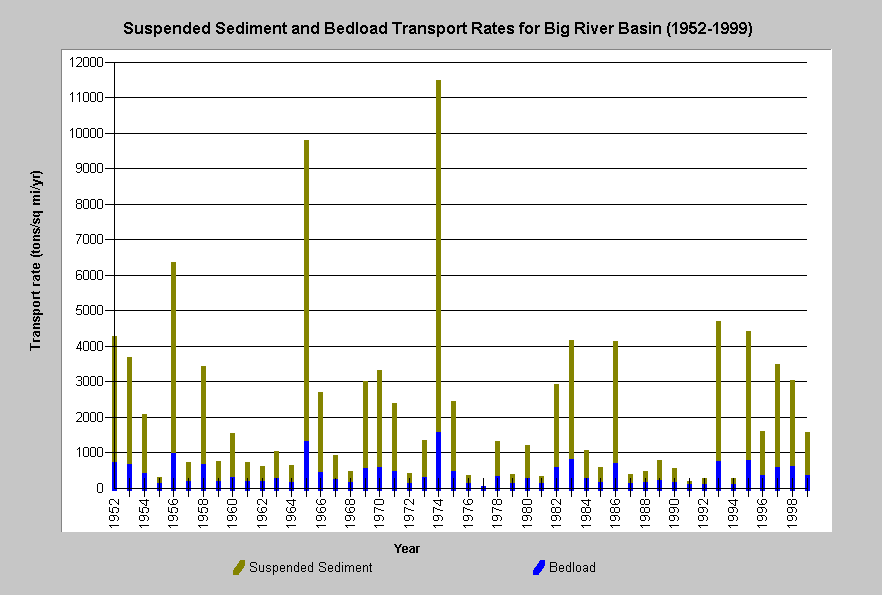 At right, suspended sediment and bedload calculations for the Big River watershed from 1952-1999. Although lower than 1955, 1964 and 1974 sediment transport, recent periods still show considerable suspended and bedload transport. A high suspended load is linked to increased turbidity, which restricts salmonid feeding and growth in winter. The elevated bedload transport is consistent with diminished pool frequency and volume. Calculations from Matthews and Associates (2001).
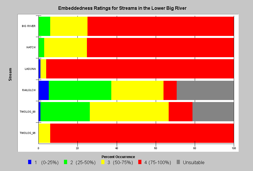 This chart shows gravel embeddedness ratings from habitat typing surveys conducted by CDFG or Georgia Pacific in lower Big River its tributaries. Embeddedness was visually rated at each pool tail to describe the depth to which gravel or cobbles were buried in fine sediment. Many sites show very high levels of embeddedness (75-100% buried). Pool tails deemed Unsuitable for spawning may be bedrock reaches but might also be areas so overwhelmed with fine sediment that there is no spawning substrate present. Few reaches had low embeddedness (0-25% buried), which is the category noted by CDFG (1998) to be suitable for salmonid spawning. Data are provided by California Department of Fish and Game, Sacramento.
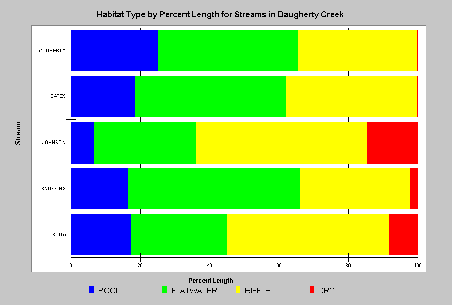 Habitat typing surveys of Daugherty Creek and its tributaries show pool frequency below 20%, which is about half of what control streams show (Murphy et al. (1984) and also half of what CDFG (1998) indicates as optimal. Both steelhead yearling and older juveniles and coho salmon require pool habitat for rearing. Lack of pools is likely limiting coho salmon and steelhead production in the Big River basin.
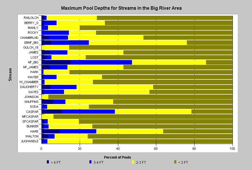 Habitat surveys of the Big River and nearby coastal streams show that there is a low occurrence of pools greater than three feet in depth. Brown et al. (1994) stressed the importance of pools deeper than a meter for successful coho rearing and steelhead yearlings also require pools of similar depth (Reeves, 1988). Note that Caspar and Hare Creek have a higher frequency of pools greater than three feet deep and that they also retain coho salmon (see Hypothesis #1). Although larger order tributaries like the North Fork Big River have deeper pools, they may also have elevated water temperature rendering habitat unsuitable for coho. Lack of pools may be caused by the lack of large woody debris brought on, in part, by former large wood removal (See Hypothesis #3).
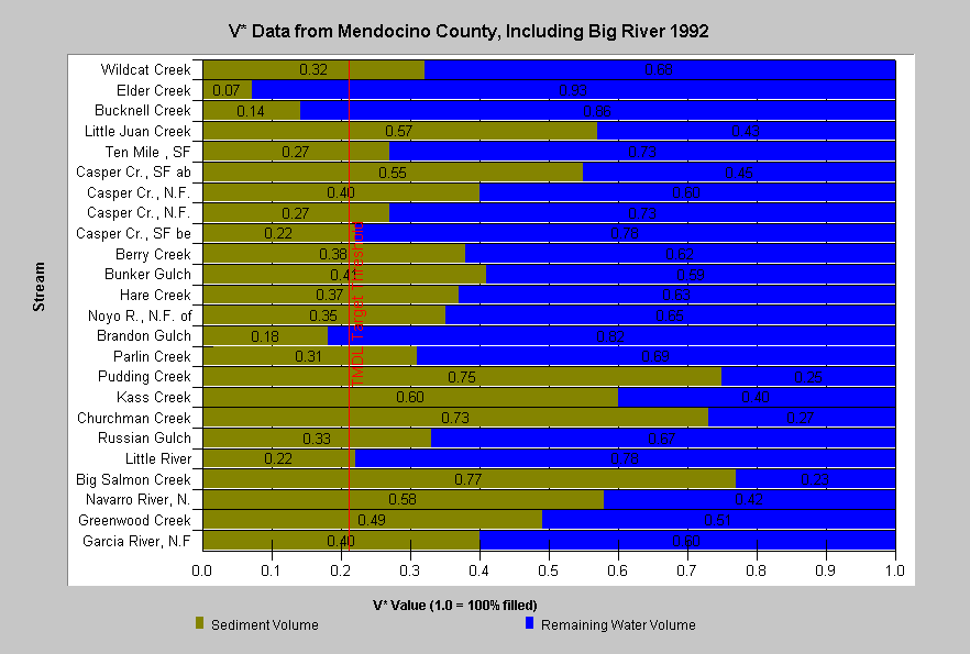 Knopp (1993) used V* techniques to measure sediment in pools at two locations in the Big River basin as well as other nearby coastal streams. Tributaries like Bunker and Berry Gulch have V* values that show moderate sediment impacts, with values nearly twice those recommended in the TMDL. Tributaries of Jackson Demonstration State Forest show a lower range than those on industrial forest lands, such as Kass or Pudding creeks, which reflect a higher degree of watershed disturbance. Those streams with a high proportion of pool volume filled with sediment are likely to be impaired with regard to coho salmon and steelhead juvenile production. Big River TMDL threshold of 0.21 is shown for reference (US EPA, 2001).
Alternative Hypotheses
Fine sediment in the Big River basin is near normal background levels.
This hypothesis has been advanced by Valentine and Jameson (1994) for the Little North Fork Noyo River. A speculative argument in support of the hypothesis reasons that the erosive geology of the region would have caused high levels of sediment prior to anthropogenic erosion and that Pacific salmon had co-evolved with these conditions. Therefore, factors other than sedimentation of streams are causing salmonid declines.
(See note on regional baseline values for fine sediment in gravels and background conditions.)
Monitoring Trends to Support or Refute the Hypothesis
A monitoring program to test the relationships between sediment, habitat and coho salmon and steelhead production would periodically measure pool frequency, pool depth, and sediment in pools (V*). Longitudinal profiles would probably be superior to habitat typing to gauge changes in pool frequency. Gravel composition (McNeils) and/or permeability and coho and steelhead juvenile standing crop should be measured annually. Trends in coho and steelhead numbers or biomass would be compared to trends in sediment and habitat metrics. If biomass or numbers of coho and steelhead salmon juveniles increase when pool depth increases and/or when fines in the substrate decreases, this would support the hypothesis. Confounding factors such as high water temperature, varying levels of large wood or cover would need to be considered. Hypothesis-based monitoring could be part of TMDL implementation: 1) implement erosion control measures, 2) monitor sediment and fish populations, 3) test hypothesis by analyzing relative trends, and 4) evaluate effectiveness of measures.
References
Barnard, 1992. Physical and Chemical Conditions in Coho Salmon (Oncorhynchus kisutch) Spawning Habitat in Freshwater Creek, Northern California. Masters Thesis. Humboldt State University, Arcata, CA. 81 p. plus appendices.
Beschta, R.L. and W.L. Jackson. 1979. The intrusion of fine sediments into a stable gravel bed. Journal of the Fisheries Research Board of Canada 36:204-210.
Boydstun, L.B. 1977. California's steelhead program. in T. Hassle and R. Van Kirk, eds. Proceedings of the genetic implications of steelhead management symposium, 1977. Calif. Coop. Fish. Res. Unit special report 77-1. pp. 26-30.
Brown, L.R., P.B. Moyle and R.M.Yoshiyama, 1994. Historical Decline and Current Status of Coho Salmon in California. North American Journal of Fisheries Management. 14( 2) 237-261.
Burns, J. 1972. Some Effects of Logging and Associated Road Construction on Northern California Streams. Transactions of the American Fisheries Society, Vol. 101, No. 1: 1-17.
California Department of Fish and Game. 1998. California Salmonid Stream Habitat Restoration Manual. Third Edition. Inland Fisheries Division. California Department of Fish and Game. Sacramento, CA. 495 p.
Chapman. D.W. 1988. Critical Review of Variables Used to Define Effects of Fines in Redds of Large Salmonids. Transactions of the American Fisheries Society. 117: 1-21.
Gallagher, S.P. 2000. (Draft) Results of the winter steelhead (Oncorhynchus mykiss) spawning survey on the Noyo River, California with comparison to some historic habitat information. California Department of Fish and Game. Steelhead Research and Monitoring Program. Fort Bragg, CA. 29 pp.
Knopp, C. 1993. Testing Indices of Cold Water Fish Habitat. Final Report for Development of Techniques for Measuring Beneficial Use Protection. North Coast Region Water Quality Control Board in cooperation with California Department of Forestry. 57 pp.
Kondolf, G.M. 2000. Assessing Salmonid Spawning Gravel Quality. Trans. Am. Fish. Soc. 129:262-281.
Manning, D.J. 2000. Carrying Capacity and Limiting Habitat Analysis for Coho Salmon (Oncorhynchus kisutch) in Streams of Northwestern California. Masters Thesis, Humboldt State University, Arcata, CA. 111p.
Matthews and Associates.2001. Preliminary Sediment Budget Analysis for the Big River. Performed under contract for Tetra Tech and the U.S. EPA. Graham Matthews and Associates, Weaverville, CA.
McHenry, M.L., D.C. Morrill and E. Currence. 1994 . Spawning Gravel Quality, Watershed Characteristics and Early Life History Survival of Coho Salmon and Steelhead in Five North Olympic Peninsula Watersheds. Lower Elwha S'Klallam Tribe, Port Angeles, WA. and Makah Tribe, Neah Bay, WA. Funded by Washington State Dept. of Ecology (205J grant).
McNeil, W. J. and W.H. Ahnell. 1964.Success of Pink Spawning Relative to Size of Spawning Bed Material. U.S. Fish and Wildlife Service, Special Scientific Report-Fisheries No. 469. Washington, D.C. 17 pp.
Murphy, M.L., J.F. Thedinga, K.V. Koski and G.B. Grette. 1984. A stream ecosystem in an old growth forest in southeast Alaska: Part V. Seasonal changes in habitat utilization by juvenile salmonids. In Proceedings of Symposium on Fish and Wildlife in Relationships in Old Growth Forests. Eds. W.R. Meehan, T.R. Merrill and T.A. Hanley. American Institute of Fishery Research Biologists, Asheville, North Carolina.
Pacific Watershed Associates. 1999. Sediment Source Investigation and Sediment Reduction Plan for the Freshwater Creek Watershed, Humboldt County, California. Performed under contract to the Pacific Lumber Company. PWA, Arcata, CA. 94 p.
Reeves, G.H.1988. Distribution patterns of fish in the Elk River basin. COPE Report l(3): 4-6.
Valentine, B.E. and M. Jameson. 1994. Little North Fork Noyo Fishery Study, 1992. CA Department of Forestry and Fire Protection, Coast Cascade Region. Santa Rosa, CA. 48 pp.
US Environmental Protection Agency (USEPA). 1998. (Final) Garcia River Sediment Total Maximum Daily Load. Dated 16 March 1998. USEPA, Region IX. San Francisco, CA. 51 pp.
U.S. Environmental Protection Agency. 2000. Ten Mile River, Total Maximum Daily Load for Sediment. Region IX. San Francisco, CA. 89 pp. Summary and Responses. 18 pp.
U.S. Environmental Protection Agency. 2001. Big River, Total Maximum Daily Load for Sediment. Region IX. San Francisco, CA. Figure 1 (Map). Summary and Responses. 18 pp.