 |
 |
| Background | Hypotheses | Bibliography | Maps | Home |
|
|
| Background | Hypotheses | Bibliography | Maps | Home |
KRIS Big River Map: Fish and
Aquatic Habitat View
![]()
This KRIS Big River Map project view is comprised of themes such as fish distribution, aquatic monitoring locations, habitat typing, large wood removal, hydrology and stream gradient. Distribution maps of presence and absence of coho salmon and steelhead trout were developed by Jackson Demonstration State Forest and assimilated into this view. The California Department of Fish and Game provided habitat typing data which is the basis of map themes. Hawthorne Timber Company and the Mendocino Redwood Company provided maps of their monitoring locations for fish and other aquatic vertebrate species as well as sites for sediment, temperature and aquatic invertebrate monitoring (Ambrose et al., 1996; Ambrose and Hines, 1996 and 1997; Hines, 2000). Knopp's (1993) sediment sampling locations are also found as a theme in this View. The U.S. Geologic Survey topographic map are used as a reference theme in this project.
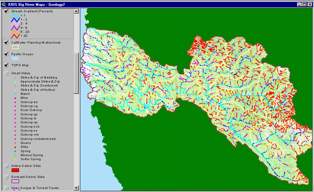 |
This image from the KRIS Big River ArcView project shows the stream gradient, which was derived from 10 meter DEM data using algorithms derived by CDF FRAP. Stream gradient is very useful for analyzing likely historic distribution of coho salmon. Note that mainstem reaches are less than 2% gradient (light or dark blue) along almost their entire extent, which is ideal for coho spawning and rearing. Coastal tributaries covered in the project, such as Caspar and Hare Creek, also have optimal gradient for coho. Steelhead may use streams with a 4% to 8% gradient. Geologists consider the 8-20% (orange) gradient reaches to be transport reaches and those above 20% (red) as supply reaches. The low gradient reaches favored by salmon and steelhead are called response reaches by geologists. |
|
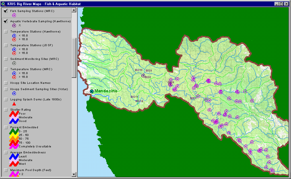
The image at left shows the KRIS Big River project area, including coastal tributaries to the north and south, with fish sampling locations of Mendocino Redwood Company and aquatic vertebrate sampling locations of Hawthorne Timber Company. For results of vertebrate sampling, see Fish Population Information in KRIS Big River and Amphibian Information in KRIS Big River |
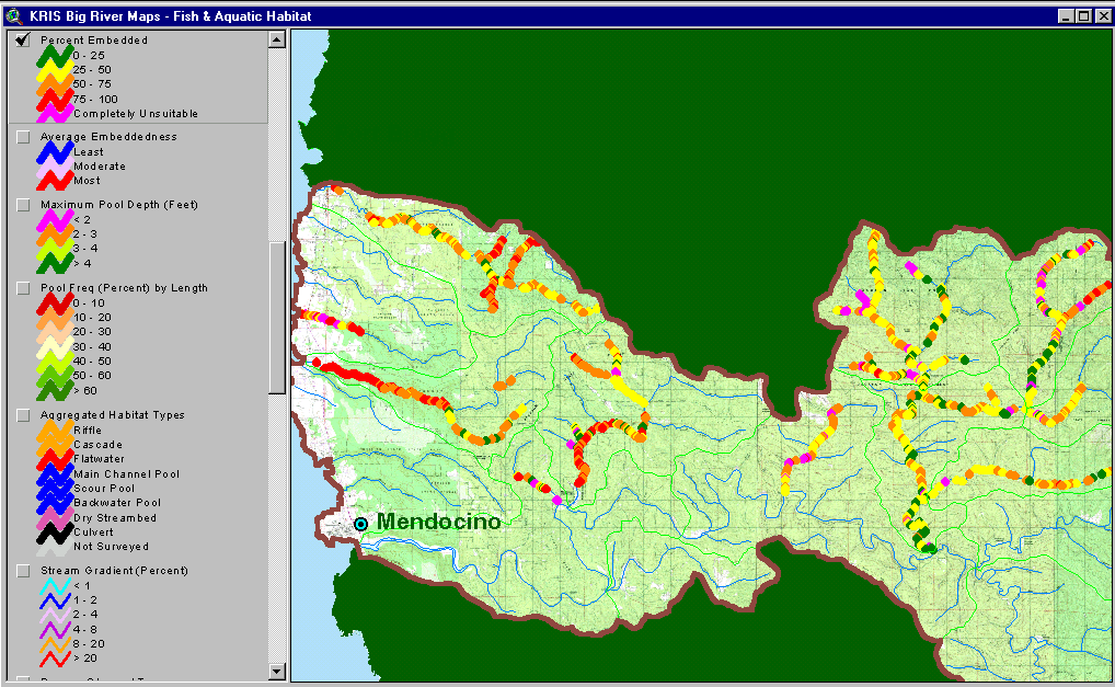 |
The image at left shows habitat typing results derived from California Department of Fish and Game data. The percent embeddedness which is displayed indicates the quality of spawning gravels. Optimal spawning values are less than 25% (green) but categories with higher embeddedness are more prevalent in the reaches surveyed. To learn more about embeddedness see Habitat Typing Information in KRIS Big River. |
 |
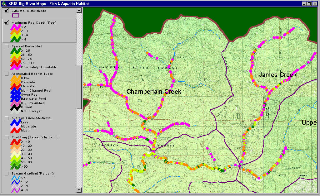
This image provides a close up percent embeddedness of the North Fork of Big River, including the Chamberlain and James Creek tributaries. Embeddedness values were relatively good in lower reaches of James Creek, where many habitats measured less than 25% embedded (green). High embeddedness may be a limiting factor for salmon and steelhead in many reaches of Chamberlain Creek. |
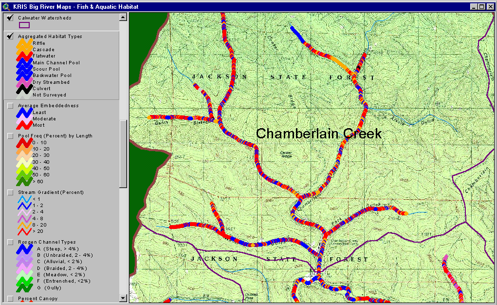 |
This map image shows aggregated habitat types for Chamberlain Creek, a tributary of the North Fork of Big River, based on California Department of Fish and Game data. All pool types are colored blue, riffles and cascades orange and flatwater habitats red. The purpose of the map is to easily distinguish pool dominated reaches. Pools are important habitat for juvenile coho salmon and steelhead trout. Consequently, pool frequency is an indicator of habitat quality and lack of pools is a potentially limiting factor. |
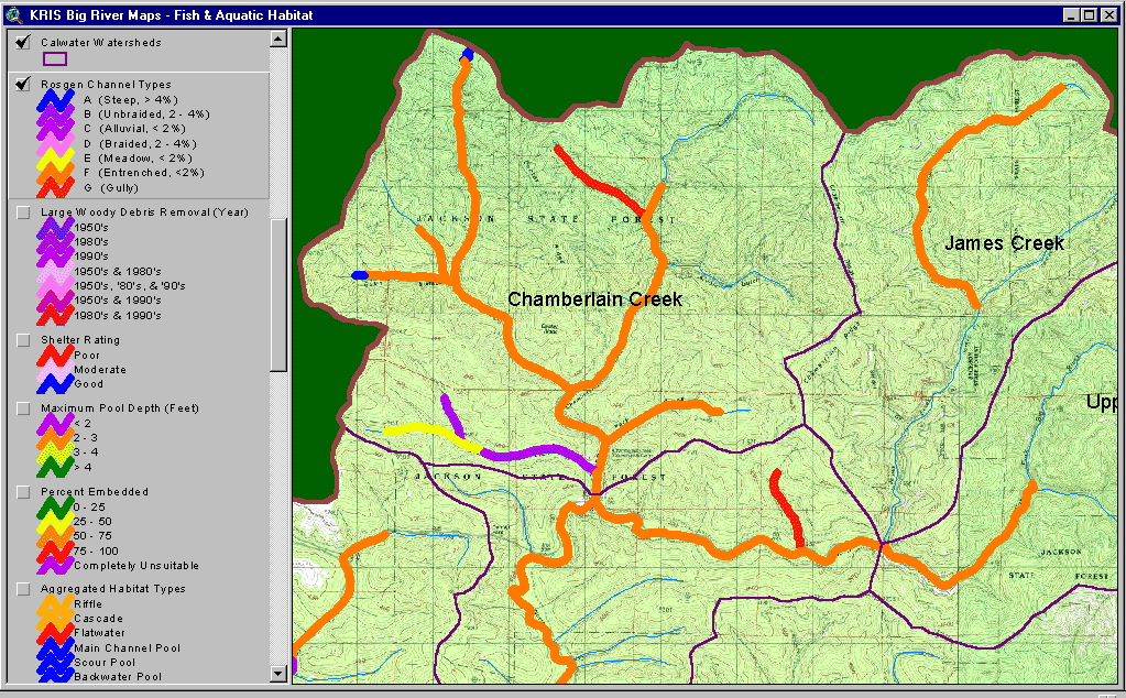 |
The image at left displays Rosgen channel types for the North Fork of Big River, including the Chamberlain and James Creek tributaries, based on California Department of Fish and Game data. The prevalence of entrenched channels reflects the history of splash damming and intensive logging in the basin. |
 |
This image shows where large wood was removed as part of stream clearance projects in the North Fork of Big River, including the Chamberlain and James Creek tributaries. Large wood was thought to impede fish passage, while its role in adding complexity to fish habitat was overlooked. See Stream Clearance in the Big River for more information. Data provided by the Jackson Demonstration State Forest. |
 |
This map image displays maximum pool depth for the North Fork of Big River, including the Chamberlain and James Creek tributaries, based on California Department of Fish and Game data. Brown et al. (1994) suggest that pools greater than one meter (about three feet) deep are required by coho salmon. Pools 3-4 feet deep are displayed in light green while those deeper than four are in dark green. Larger order streams such as the North Fork Big River, which flows from right to left in the image, have deeper pools than smaller tributaries which join it from the north. James Creek appears to have a slightly higher frequency pools deeper than three feet than Chamberlain Creek. See Habitat Typing Information in KRIS Big River for more information. |
![]()
References
California Department of Fish and Game (CDFG). 1995a. Hare Creek (Pacific Ocean tributary) stream inventory report, text only. CDFG unpublished file memo by unknown author. Fortuna, CA. 16 pp.
California Department of Fish and Game (CDFG). 1995b. Little North Fork Big River stream inventory report, text only. CDFG unpublished file memo by unknown author. Fortuna, CA. 11 pp.
California Department of Fish and Game (CDFG). 1995c. South Fork Hare Creek (Hare Creek tributary) stream inventory report, text only. CDFG unpublished file memo by unknown author. Fortuna, CA. 10 pp.
California Department of Fish and Game (CDFG). 1995d. Unnamed South Fork Hare Creek tributary stream inventory report, text only. CDFG unpublished file memo by unknown author. Fortuna, CA. 4 pp.
California Department of Fish and Game (CDFG). 1996. James Creek (North Fork Big River tributary) stream inventory report, text only. CDFG unpublished file memo by unknown author. Fortuna, CA. 11 pp.
California Department of Fish and Game (CDFG). 1997a. Gulch Sixteen, tributary to West Chamberlain Creek, tributary to Chamberlain Creek (North Fork Big River tributary) stream inventory report, text only. CDFG unpublished file memo by unknown author. Fortuna, CA. 11 pp.
California Department of Fish and Game (CDFG). 1997b. North Fork Big River (Big River tributary) stream inventory report, text only. CDFG unpublished file memo by unknown author. Fortuna, CA.
California Department of Fish and Game (CDFG). 1997c. Two Log Creek (Big River tributary) stream inventory report, text only. CDFG unpublished file memo by unknown author. Fortuna, CA. 10 pp.
California Department of Fish and Game (CDFG). 1997d. Unnamed Gulch Sixteen tributary, tributary to West Chamberlain Creek, tributary to Chamberlain Creek, a North Fork Big River tributary, stream inventory report, text only. CDFG unpublished file memo by unknown author. Fortuna, CA. 3 pp.
California Department of Fish and Game (CDFG). 1998. East Branch North Fork Big River stream inventory report, text only. CDFG, Northern California and North Coast Region. Fortuna, CA. 22 pp.
California Department of Fish and Game (CDFG). 1999. Hare Creek (Pacific Ocean tributary) stream inventory report, September 1999. CDFG, Northern California and North Coast Region. Fortuna, CA. 22 pp.
Knopp, C. 1993. Testing Indices of Cold Water Fish Habitat. Final Report for Development of Techniques for Measuring Beneficial Use Protection and Inclusion into the North Coast Region's Basin Plan by Amendment of the.....Activities, September 18, 1990. North Coast Regional Water Quality Control Board in cooperation with California Department of Forestry. 57 pp.
![]()
| www.krisweb.com |