
| Area | Basinwide/Regional |
| Topic | Sediment: Matthews Landslides Delivered by Type 1921-2000 |
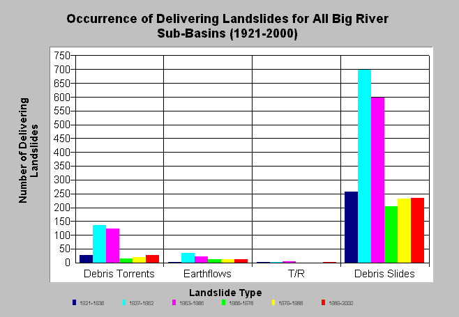
| Caption: The chart above shows the type and occurrence of landslides that have delivered sediment to streams in the Big River basin (T/R=Translational/Rotational). A total of 2669 slides were determined to have delivered in the study period (1921-2000) resulting in a watershed-averaged rate of 14.7 delivering slides/sq mi (Matthews and Associates 2001). The slides were mapped from aerial photographs. The first period is estimated to cover features spanning back to 1921 and the other periods are those bracketed by the aerial photo years. Debris slides and debris torrents are the most common features. The actual number of slides in the 1921-1936 period is likely an underestimate, since 1936 aerial photo coverage was unavailable for the eastern half of the watershed. Click on Info Links for more information. | |
 |
To learn more about this topic click here .
To view the table with the chart's data, click Chart Table web page.
To download the table with the chart's data, click slide_type_byperiod.dbf (size 554 bytes) .
To see meta information about the data table used for this topic click here
| www.krisweb.com |