 |
 |
| Background | Analysis | Bibliography | Maps | Home |
| |
|
| Background | Analysis | Bibliography | Maps | Home |
KRIS Web Background Pages: Habitat Types
![]()
The KRIS Gualala CD contains habitat typing data from stream surveys conducted by California Department of Fish and Game (CDFG) following protocols described in CDFG (1998).CDFG habitat typed approximately 100 miles of Gualala River tributaries in 2001 and that data provides a adequate insight into fish habitat conditions (CA RA, In Review). All surveys in the basin in 2001 were conducted by the same crew.
Several types of charts are displayed in KRIS Gualala to summarize habitat conditions. CDFG habitat survey protocol involves classifying habitat units and describing 15 attributes for each unit, or a sample of each unit type. Summary data and charts in KRIS Gualala show habitat frequency-by-length, maximum pool depth, pool tail embeddedness, and percent canopy cover. Summary charts in KRIS Gualala display habitat data for all surveyed streams in the Gualala River basin-wide and by subbasin. This comparative chart style is more useful for analysis of conditions at the watershed or basin scale.
Larger streams generally have more open canopy and deeper pools than small streams. This is a function, at least in part, of wider stream channels and greater stream energy due to higher discharge during storms. KRIS charts list streams on the vertical axis in descending order by Strahler stream order to allow some resolution on this size factor (see Stream Order). By such a presentation, one would expect a trend in canopy cover and pool depth values. Deviations from the expected trend in canopy or pool depth may indicate streams with more suitable or unsuitable canopy or pool depth conditions relative to other streams of that subbasin. For substantive discussions on analysis of habitat typing data from streams in the Mendocino coast hydrologic unit (Gualala River to Ten Mile River), see (CRWQCB, 2001).
Multiple reaches of different channel types were surveyed in only three Gualala streams (the Little North Fork, Dry Creek, and Buckeye Creek). In these cases, charts present summary values for all three reaches combined.
|
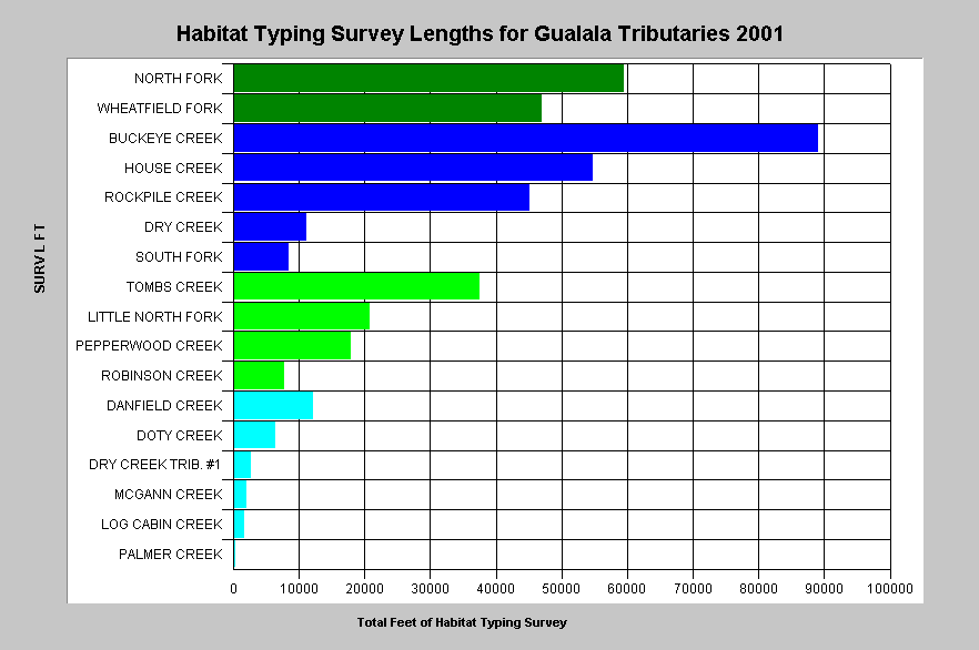
Surveys lengths can vary greatly, as illustrated by this chart which shows the total length in feet of all California Department of Fish and Game Habitat Typing surveys for Gualala basin reaches in 2001. Buckeye Creek had the longest survey length with over 89,000 feet covered. Only 395 feet of Palmer Creek was surveyed. Shorter surveys may yield summary parameters that less accurately represent habitat conditions. Stream orders of tributaries using the Strahler method were determined using 1:24000 USGS Topo maps and are color coded above with dark green = 5th order, dark blue = 4th order, light green = 3rd order, light blue = 2nd order. |
Summary Charts for Habitat Type Frequency
Habitat frequency can be used to roughly gauge problems of cumulative watershed effects on streams. When substantial erosion occurs in a watershed, pool habitats diminish by aggradation (filling in) (Madej, 1984). Subsequent habitat surveys will find the stream dominated by riffles or flatwater units (shallow glides and runs). Flatwater habitats may still be suitable for young of the year steelhead, but young coho salmon require pools, preferably with large wood.
Habitat typing summaries in KRIS combine the 22 total habitat types into four simpler categories: pools, riffles, flat water habitats and dry areas. These are consistent with CDFG level II habitat types. Habitat frequency by length is used instead of percent occurrence because the latter has less relevance to habitat availability and is less sensitive to cumulative effects. For example, streams that are aggraded may still have numerous, shallow pools of short length and a few very long runs and riffles.
|
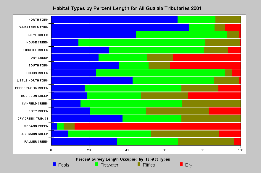
This chart shows the relative length, by basic habitat type, of surveys in the Gualala basin in 2001 by the California Department of Fish and Game. Pool habitat (blue) predominates in the higher order streams at the top of the chart, except that House Creek has less than 20% of its habitat occurring as pools. Pool frequency of many lower order streams is low with Doty, Danfield, Robinson and Pepperwood all having values less than 20% by length. Although 2001 was a dry year, extensive dry reaches are consistent with a hypothesis of aggradation in the Gualala basin. |
Summary Charts for Maximum Pool Depth
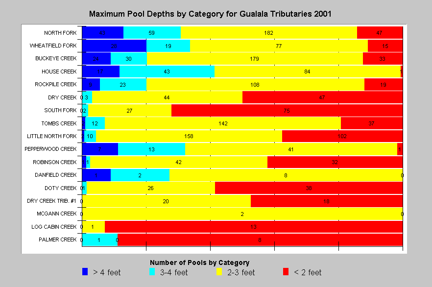
Brown et al. (1994) suggested that pools of one meter (approximately 3 feet) in depth or greater were necessary for successful rearing of coho salmon juveniles. Older age steelhead also rely on pool habitat. Chen (1992) based cumulative effects models for the Elk River, Oregon on whether three-foot-deep pools were being maintained. His hypothesis was that if pools were greater than three feet they would support yearling steelhead.
Maximum pool depth is a discrete attribute with minimally subjective criteria for evaluation in the field. Summary charts in KRIS Gualala display pool depth categories to discern how many pools deeper than three feet exist in surveyed areas. The ranking of streams by size enables the viewer to account for the fact that larger streams naturally have deeper pools due greater flow and energy.
|
California Department of Fish and Game surveys of the Gualala River in 2001 measured maximum depth for every pool surveyed. The chart at left shows that pool depth is restricted. Fifth Order streams like the North Fork and Wheatfield had few pools deeper than four feet. Smaller streams were dominated by pools less than three feet and a high occurrence of pools measuring less than two feet deep. Streams are listed by stream order with larger streams near the top |
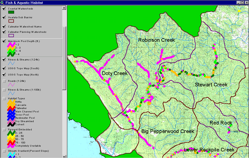 |
The image at left shows displays maximum pool depths for the North Fork Gualala subbasin. The predominance of pools less than two feet deep in the Little North Fork, Doty Creek, Dry Creek, and Robinson Creeks (located in upper Robinson Calwater) represents unsuitable rearing habitat for coho and older age steelhead, and is consistent with the hypothesis of aggradation. Despite its large size, the North Fork has many pools less than two feet deep. Map image based on California Department of Fish and Game data and taken from the KRIS Gualala Map project. |
Summary Charts for Embeddedness
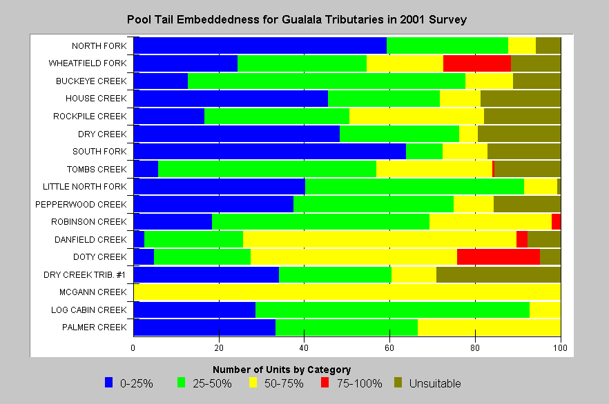
Pool tail embeddedness is a simple but subjective means of evaluating salmonid spawning habitat quality in the field. Pools tail crests are measured visually to determine to what degree potential spawning gravels might be embedded (partially buried). The California Department of Fish and Game (1998) categorize gravels less than 25% embedded as optimal for salmonid spawning. Other categories are 25-50%, 50-75% and greater than 75%. A fifth category is used to describe pool tails otherwise unsuitable for spawning (log, plank, rock, concrete sill, bedrock sheet, etc.). High embeddedness is generally caused by an excessive supply of sediment to the stream. Embeddedness estimates are visual and involve some subjectivity. The method is somewhat reliable for showing differences in habitat conditions among streams surveyed by the same observers, and much less reliable for strictly classifying habitat conditions or showing differences among streams surveyed by different observers. By contrast, bulk gravel (McNeil) or permeability samples are much more rigorous in describing spawning and incubation habitat conditions (see Sediment Background page).
|
This chart shows the degree to which potential salmonid spawning substrate at pool tails is buried or embedded according to 2001 California Department of Fish and Game habitat typing surveys in the Gualala basin. The best values for salmonid spawning appear in the South Fork and North Fork Gualala reaches surveyed, while other streams like Doty Creek and Danfield Creek show relatively impaired conditions. |
|
|
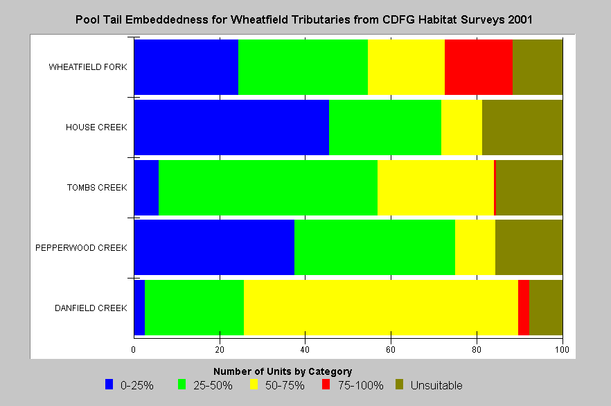
This chart shows the degree to which potential salmonid spawning substrate at pool tails is buried or embedded according to 2001 California Department of Fish and Game habitat typing surveys in the Wheatfield subbasin. The best values for salmonid spawning appear in House Creek with Pepperwood Creek, with the mainstem Wheatfield also showing some optimal measurements. Tombs Creek and Danfield Creek show relatively impaired conditions for salmonid spawning. |
|
|
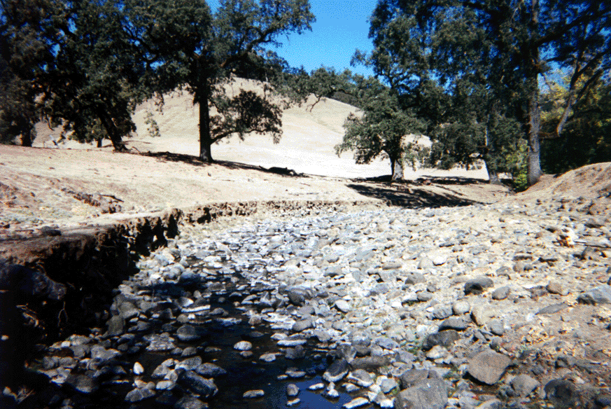
This picture shows a low gradient riffle with little shelter for fish in Danfield Creek, a tributary of the Wheatfield Fork Gualala. Particle size on the stream bed is large cobble, which appears partially buried or embedded. Embeddedness is generally measured at pool tail crests because they are favored salmonid spawning habitat, although riffle habitats are also used for spawning. High embeddedness is caused by excessive sediment supply to a stream. Photo provided courtesy of Cynthia LeDoux Bloom of the California Department of Fish and Game, North Coast Watershed Assessment Program. |
Summary Charts for Canopy Cover
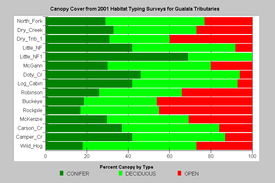
Canopy is an indicator of whether there is direct shade on a stream. Surveyors measure canopy from the middle of the stream using a densiometer (CDFG, 1998). The California Department of Fish and Game (1998) recognizes that "stream canopy should be approximately 80 percent to maintain suitable water temperatures" for salmonids, but that optimal canopy conditions may involve less total canopy in fourth order and large streams.
Shade is important for keeping streams cool, but it is less important than air temperature in determining stream temperature. Air temperature over the stream can be moderated by topography and vegetation that maintains a microclimate. Large coniferous trees are particularly effective at maintaining microclimate, and microclimate may be negatively effected, even if shade is maintained, by harvest of large overstory trees back from the immediate stream edge (see Riparian Information in KRIS Gualala). Small diameter conifers and hardwoods also provide a very low quality and longevity of wood for aquatic habitat diversity (Cedarholm et al., 1996).
More than half the survey reaches from 2001 California Department of Fish and Game habitat typing had less than 80% canopy. In addition, the existing canopy is often comprised mostly of deciduous trees as opposed to conifers.
|
This
chart shows canopy cover for all Gualala River tributaries surveyed in 2001
by the California Department of Fish and Game. While total canopy is relatively
high for many reaches, the canopy is composed of primarily deciduous trees
instead of conifers. In eastern and southeastern basins, such as the McKenzie
Creek, a high deciduous component may be a natural condition due to geology;
but in western basins, such as lower Rockpile Creek or Robinson Creek, lack
of conifers is as a result of past and recent management.
|
|
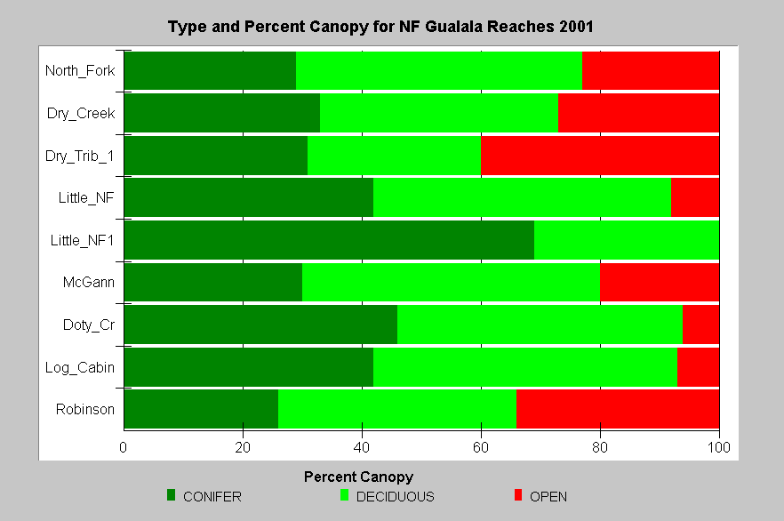
This chart shows the canopy cover for the North Fork Gualala tributaries surveyed in 2001 by the California Department of Fish and Game. Dry Creek, Dry Tributary #1, and Robinson Creek have open canopy values of 30-40% which allows stream warming. All these reaches lie within coniferous forests and the high component of deciduous trees in the riparian is not a natural condition. |
![]()
References
Brown, L.R., P.B. Moyle, and R.M. Yoshiyama. 1994. Historical Decline and Current Status of Coho Salmon in California. North American Journal of Fisheries Management. 14(2):237-261.
Byrne, M. 1997. California Salmonid Habitat Inventory: a Dynamic Segmentation Application. Earth Science Research Institute (ESRI), 1997 Annual Proceedings of ESRI Conference. CDFG, Inland Fisheries, Sacramento, CA.
California Regional Water Quality Control Board (CRWQCB). 2001. Assessment of aquatic conditions in the Mendocino coast hydrologic unit. North Coast Region, CRWQCB. Santa Rosa, CA. 284 pp.
California Resources Agency. In Review. Gualala River Watershed Synthesis. CA Dept. of Fish and Game, State Water Res. Control Bd., CA Dept. of Water Resources, CA Div. on Mines and Geology and CA Dept. of Forestry. Sacramento, CA. Draft released January 16, 2001.
CA Department of Fish and Game. 1998. California Salmonid Stream Habitat Restoration Manual. Third Edition. Inland Fisheries Division. California Department of Fish and Game. Sacramento, CA. 495 p.
Cederholm, C.J., R.E. Bilby, P.A. Bisson, T.W. Bumstead, B.R. Fransen, W.J. Scarlett, and J.E. Ward. 1997. Response of Juvenile Coho Salmon and Steelhead to Placement of Large Woody Debris in a Coastal Washington Stream. North American Journal of Fisheries Management. 17(4): 947-963.
Chen,G. 1992. Use of Basin Survey Data in Habitat Modeling and Cumulative Watershed Effects Analysis. Siskiyou NF. Published as part of USDA Forest Service Region 5 Fish Habitat Relationship Technical Bulletin Series, No. 8.
Madej, M. 1984. Recent changes in channel-stored sediment Redwood Creek, California. Redwood National Park Technical Report #11, Arcata, CA. 54 p.
Poole, G.C., and C.H. Berman. 2000. Pathways of Human Influence on Water Temperature Dynamics in Stream Channels. U.S. Environmental Protection Agency, Region 10. Seattle, WA. 20 p.
![]()
| www.krisweb.com |