
| Area | Basin-wide/General |
| Topic | Climate: Annual Rainfall in Fort Ross 1878-2000 |
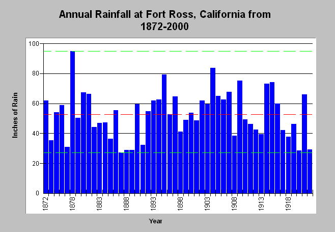
| Caption: The graph above shows annual rainfall in inches in Fort Ross, California from 1872-2000, except for 1875 which was not recorded. Bounding lines show highest (94.75 inches) and lowest rainfall (16.01) totals with red line indicating mean annual rainfall (approximately 43 inches). Major drought cycles are indicated in the late 1920s-early 1930s, 1976-77 and 1987-1994. Wet years are more likely to trigger erosion than dry, although storm intensity and landscape conditions are also significant factors. The rainfall in the earlier periods of record prior to 1920 seems to be consistently higher than those after that period, although the rain gauge type was changed in 1939. See Info Links for more information. | |
 |
To learn more about this topic click Info Links .
To view a table of information about this data click Metadata .
To view the table with the chart's data, click Chart Table web page.
To download the table with the chart's data, click rain_fortross.dbf (size 5,346 bytes) .
To view the table with the chart's source data, click Source Table web page.
To download the table with the chart's source data, click rainfall_gualala.dbf (size 5,193 bytes)
| www.krisweb.com |