
| Area | Basin-wide/General |
| Topic | Sediment: V* Knopp Results for Two Reaches in Gualala River, 1992 |
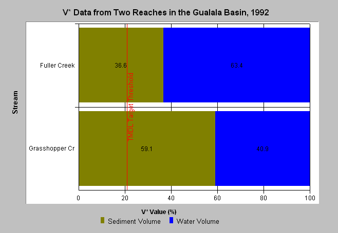
| Caption: This chart displays V* data from two Gualala River tributaries, Fuller and Grasshopper creeks as measured in 1992. Both Fuller and Grasshopper Creeks have significantly elevated sediment loads over background levels, although Fuller Creek is in more advanced recovery from sediment impacts than Grasshopper Creek. The TMDL V* target for this basin is 21%. A V* of 50% indicates that half of the pool is filled with fine sediment. See the Source Table for other indices used and sites studied by Knopp (1993). The North Coast Regional Water Quality Control Board provided data. See Info Links for more information. | |
 |
To learn more about this topic click Info Links .
To view a table of information about this data click Metadata .
To view the table with the chart's data, click Chart Table web page.
To download the table with the chart's data, click knopp_gulala.dbf (size 936 bytes) .
To view the table with the chart's source data, click Source Table web page.
To download the table with the chart's source data, click knopp.dbf (size 12,582 bytes)
| www.krisweb.com |