
| Area | Basin-wide/Regional |
| Topic | Sediment: Fines <4.7 mm at All Humboldt Bay Sampling Sites 1994-1999 |
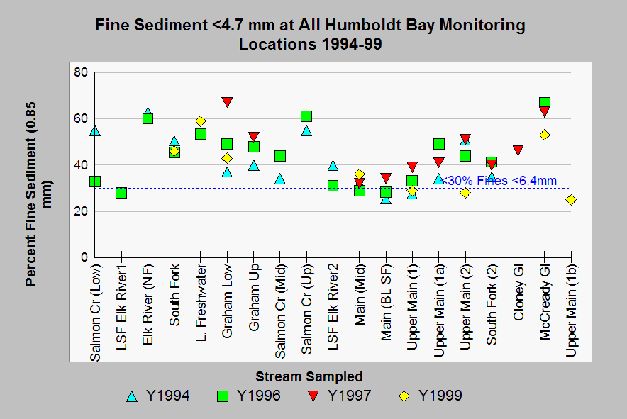
| Caption: This chart shows all fine sediment data from PL monitoring sites from 1994-1999 for particles less than 4.7 mm, which tends to lodge in the gravel matrix and block emergence of salmonid fry. The reference line of 30% fines is similar to that chosen to represent properly functioning condition for cold water fish by the U.S. EPA (1998) in TMDL studies, but measurements apply to fine gravel and sand less than 6.4 mm. Few Humboldt Bay sites fell within optimal ranges according to this criterion. See Info links for more information on fine sediment and aquatic health. Data from the PALCO. | |
 |
To learn more about this topic click Info Links .
To view additional information (data source, aquisition date etc.) about this page, click Metadata .
To view the table with the chart's data, click Chart Table web page.
To download the table with the chart's data, click sed_fines_47mm_94_99.dbf (size 1,550 bytes)
To download the table with the chart's data as an Excel spreadsheet, click sed_fines_47mm_94_99.dbf.xls (size 6,144 bytes) .
| www.krisweb.com |