
| Area | Elk River |
| Topic | Sediment: Fines <4.7 mm Elk River 1994-96 |
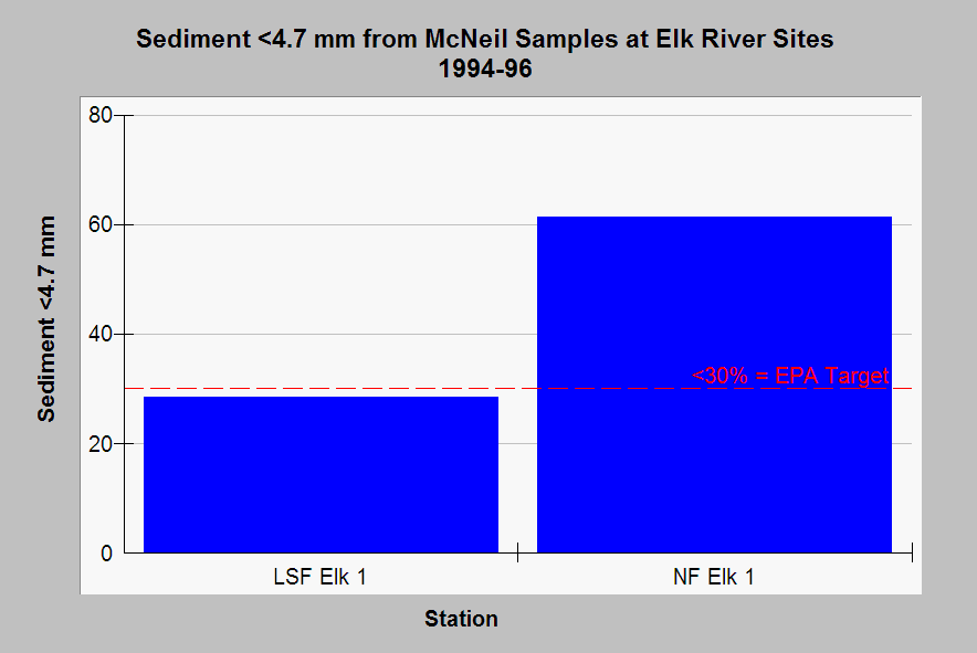
| Caption: This chart shows levels of fine sediment less than 4.7 mm in the Little South Fork and North Fork Elk River. U.S. EPA (1998) recognizes fines less than 6.4 mm as harmful to salmonid spawning and sets a target of less than 30% to meet beneficial use for cold water fish spawning. High levels of sand may be partly a result of sandstone lithology but extensive timber harvest in the watershed has also occurred. Data from PALCO Habitat Conservation Plan (1998). Click on Picture to see the location of sites. See Info Links for more discussion of sediment sampling. | |
 |
To learn more about this topic click Info Links .
To view additional information (data source, aquisition date etc.) about this page, click Metadata .
To view the table with the chart's data, click Chart Table web page.
To download the table with the chart's data, click errdsed.dbf (size 1,250 bytes)
To download the table with the chart's data as an Excel spreadsheet, click errdsed.dbf.xls (size 3,584 bytes) .
| www.krisweb.com |